IMAGES TAKEN NEAR TO
Aldene Way, NOTTINGHAM, NG14 6ET
Introduction
This page details the photographs taken nearby to Aldene Way, NG14 6ET by members of the Geograph project.
The Geograph project started in 2005 with the aim of publishing, organising and preserving representative images for every square kilometre of Great Britain, Ireland and the Isle of Man.

There are currently over 7.5m images from over14,400 individuals and you can help contribute to the project by visiting https://www.geograph.org.uk
Image Map
Images are licensed for reuse under creativecommons.org/licenses/by-sa/2.0
Notes
- Clicking on the map will re-center to the selected point.
- The higher the marker number, the further away the image location is from the centre of the postcode.
Image Listing (49 Images Found)
Images are licensed for reuse under creativecommons.org/licenses/by-sa/2.0
Image
Details
Distance
1
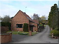
Farm conversion
The courtyard farms which once lined Main Street have been entirely converted into modern dwellings.
Image: © Alan Murray-Rust
Taken: 20 Mar 2011
0.09 miles
2
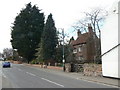
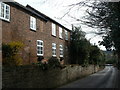
House on Main Street
Like several of the buildings along this stretch of Main Street, it appears to have belonged to a courtyard farm whose fields would have been outside the village.
Image: © Alan Murray-Rust
Taken: 20 Mar 2011
0.10 miles
3
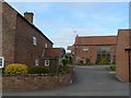
Farm conversion
The small farmhouse (left) and its barns have been converted into modern dwellings.
Image: © Alan Murray-Rust
Taken: 20 Mar 2011
0.10 miles
5
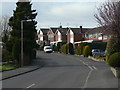
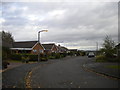
Dover Beck Drive
1970s residential development, part of the expansion of Woodborough as a commuter dormitory for Nottingham.
Image: © Alan Murray-Rust
Taken: 20 Mar 2011
0.11 miles
6
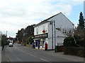
Woodborough Post Office
Originally the Woodborough Industrial and Provident Society. Currently the only shop in the village. The Post Office moved here from premises opposite the church.
Image: © Alan Murray-Rust
Taken: 20 Mar 2011
0.12 miles
7
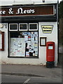
Woodborough Post Office postbox ref: NG14 217
Later style of EIIR pillar box. Probably erected here when the Post Office moved from its previous site near the church.
Image: © Alan Murray-Rust
Taken: 20 Mar 2011
0.12 miles
8
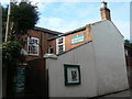
Woodborough Baptist Church
The datestone in the gable carries the date 1831. The chapel was squeezed into a plot of land 'thirteen yards from east to west and 12 yards from south to north'.
Image: © Alan Murray-Rust
Taken: 20 Mar 2011
0.12 miles
9
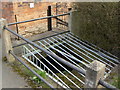
Grill above Main Street Dyke
Following the severe floods in June/July 2007 http://www.geograph.org.uk/photo/483720 , steps have been taken to ensure that this culverted stream is kept clear of debris, a contributing factor to those floods.
Image: © Alan Murray-Rust
Taken: 20 Mar 2011
0.12 miles
10
Shelt Hill
The large windows suggest that this might originally have been some sort of a workshop rather than a dwelling which it now is.
Image: © Alan Murray-Rust
Taken: 20 Mar 2011
0.12 miles