IMAGES TAKEN NEAR TO
Doverbeck Drive, NOTTINGHAM, NG14 6ER
Introduction
This page details the photographs taken nearby to Doverbeck Drive, NG14 6ER by members of the Geograph project.
The Geograph project started in 2005 with the aim of publishing, organising and preserving representative images for every square kilometre of Great Britain, Ireland and the Isle of Man.

There are currently over 7.5m images from over14,400 individuals and you can help contribute to the project by visiting https://www.geograph.org.uk
Image Map
Images are licensed for reuse under creativecommons.org/licenses/by-sa/2.0
Notes
- Clicking on the map will re-center to the selected point.
- The higher the marker number, the further away the image location is from the centre of the postcode.
Image Listing (39 Images Found)
Images are licensed for reuse under creativecommons.org/licenses/by-sa/2.0
Image
Details
Distance
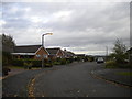
2
Dover Beck Drive
1970s residential development, part of the expansion of Woodborough as a commuter dormitory for Nottingham.
Image: © Alan Murray-Rust
Taken: 20 Mar 2011
0.09 miles
4
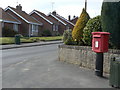
Shelt Hill postbox ref: NG14 218
On the corner of Dover Beck Drive. The latest style of EIIR free-standing small box.
Image: © Alan Murray-Rust
Taken: 20 Mar 2011
0.11 miles
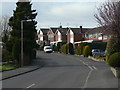
5
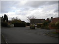
Turning area off Sunningdale Drive, Woodborough
Image: © Richard Vince
Taken: 25 Oct 2014
0.11 miles
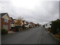
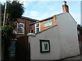
6
Shelt Hill
The large windows suggest that this might originally have been some sort of a workshop rather than a dwelling which it now is.
Image: © Alan Murray-Rust
Taken: 20 Mar 2011
0.12 miles
7
Woodborough Baptist Church
The datestone in the gable carries the date 1831. The chapel was squeezed into a plot of land 'thirteen yards from east to west and 12 yards from south to north'.
Image: © Alan Murray-Rust
Taken: 20 Mar 2011
0.13 miles
8
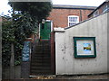
Entrance to Woodborough Baptist Church
On Shelt Hill, which is a very narrow road, hence the limited view of the building.
Image: © Richard Vince
Taken: 25 Oct 2014
0.13 miles
9
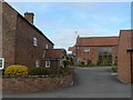
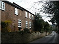
Farm conversion
The small farmhouse (left) and its barns have been converted into modern dwellings.
Image: © Alan Murray-Rust
Taken: 20 Mar 2011
0.13 miles
10
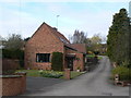
Farm conversion
The courtyard farms which once lined Main Street have been entirely converted into modern dwellings.
Image: © Alan Murray-Rust
Taken: 20 Mar 2011
0.13 miles