IMAGES TAKEN NEAR TO
Chapel Lane, NOTTINGHAM, NG14 6AQ
Introduction
This page details the photographs taken nearby to Chapel Lane, NG14 6AQ by members of the Geograph project.
The Geograph project started in 2005 with the aim of publishing, organising and preserving representative images for every square kilometre of Great Britain, Ireland and the Isle of Man.

There are currently over 7.5m images from over14,400 individuals and you can help contribute to the project by visiting https://www.geograph.org.uk
Image Map
Images are licensed for reuse under creativecommons.org/licenses/by-sa/2.0
Notes
- Clicking on the map will re-center to the selected point.
- The higher the marker number, the further away the image location is from the centre of the postcode.
Image Listing (19 Images Found)
Images are licensed for reuse under creativecommons.org/licenses/by-sa/2.0
Image
Details
Distance
1
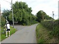
The end of the road
Beyond this point the lane becomes a private road. The public bridleway continues to the left.
Image: © Alan Murray-Rust
Taken: 12 Jul 2020
0.02 miles
2
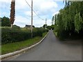
Lane to Cottage Farm
The southern end of a long bridleway through towards the village of Halam.
Image: © Alan Murray-Rust
Taken: 12 Jul 2020
0.03 miles
3
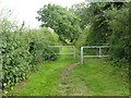
Bridleway barriers
Installed to prevent the use of motorised vehicles.
Image: © Alan Murray-Rust
Taken: 12 Jul 2020
0.06 miles
4
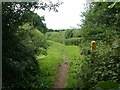
Bridleway above Epperstone
The open green lane becomes more enclosed at this point.
Image: © Alan Murray-Rust
Taken: 12 Jul 2020
0.12 miles
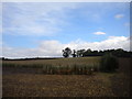
5
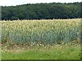
Bands of green
Colour variations – grass, wheat stems, wheat heads and woodland.
Image: © Alan Murray-Rust
Taken: 12 Jul 2020
0.12 miles
6
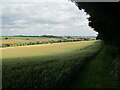
The valley of the Order Beck
Looking towards Epperstone.
Image: © Jonathan Thacker
Taken: 15 Jul 2022
0.16 miles
7
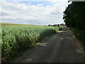
Farm tarck and footpath to Epperstone
A field of beans on the left.
Image: © Jonathan Thacker
Taken: 15 Jul 2022
0.19 miles
8
Footbridge near Epperstone
Links a permissive path to the public footpath.
Image: © Jonathan Thacker
Taken: 15 Jul 2022
0.19 miles
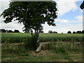
10
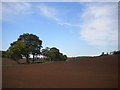
Field west of Cottage Farm (2)
The trees on the left mark the route of a track (which also hosts a public footpath) and what appears to be a drain.
Image: © Richard Vince
Taken: 9 Oct 2014
0.21 miles