IMAGES TAKEN NEAR TO
Corporation Cottages, NOTTINGHAM, NG14 5GY
Introduction
This page details the photographs taken nearby to Corporation Cottages, NG14 5GY by members of the Geograph project.
The Geograph project started in 2005 with the aim of publishing, organising and preserving representative images for every square kilometre of Great Britain, Ireland and the Isle of Man.

There are currently over 7.5m images from over14,400 individuals and you can help contribute to the project by visiting https://www.geograph.org.uk
Image Map
Images are licensed for reuse under creativecommons.org/licenses/by-sa/2.0
Notes
- Clicking on the map will re-center to the selected point.
- The higher the marker number, the further away the image location is from the centre of the postcode.
Image Listing (75 Images Found)
Images are licensed for reuse under creativecommons.org/licenses/by-sa/2.0
Image
Details
Distance
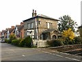
1
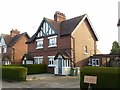
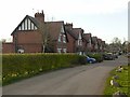
Corporation Cottages, Bulcote
One of a range of six cottage pairs, built c.1905 by Nottingham Corporation for employees at its Bulcote Farm. The range is Listed Grade II as a single entry.
Image: © Alan Murray-Rust
Taken: 22 Mar 2020
0.01 miles

3
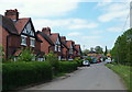
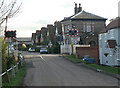
Bulcote NG14, Notts.
Four of a row of six Corporation Cottages near Bulcote railway crossing. The semi-detached cottages were built for the use of City Council employees who worked at the former Bulcote sewerage farm behind the photographer. The latter now belongs to the Severn Trent Water Authority and is rented out as agricultural farm.
Image: © David Hallam-Jones
Taken: 19 May 2013
0.01 miles
4
Corporation Cottages
Six pairs of semi-detached cottages built by Nottingham Corporation for employees at its Bulcote Farm.
Image: © Alan Murray-Rust
Taken: 14 Nov 2008
0.01 miles
5
Bulcote NG14, Notts.
The first (or last) of the row of Corporation Cottages; a railway crossing; the "Crossing House" and a grassed area through which an exposed drain runs. These semi-detached cottages, of which one is seen here, were built for the use of City Council employees who worked at the former Bulcote sewerage farm behind the photographer. The latter now belongs to the Severn Trent Water Authority and is rented out as an agricultural farm.
Image: © David Hallam-Jones
Taken: 19 May 2013
0.02 miles
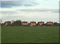
6
Corporation Cottages, Bulcote
A range of six cottage pairs, built c.1905 by Nottingham Corporation for employees at its Bulcote Farm. The range is Listed Grade II as a single entry. The nearest pair is slightly larger and would have been occupied by more senior employees. See also http://www.geograph.org.uk/photo/6423282
Image: © Alan Murray-Rust
Taken: 22 Mar 2020
0.03 miles
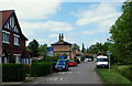
7
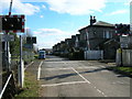
Bulcote crossing
There was clearly a crossing here long before the buildings on the far side of the crossing were built, as the old crossing keeper's cottage shows. The crossing would have become more important with the development of the large farm which can be seen in the distance. This is part of the extensive farm developed as part of the City of Nottingham's sewage disposal system based on the Stoke Bardolph works.
Image: © Alan Murray-Rust
Taken: 14 Nov 2008
0.04 miles
10
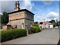
Bulcote Crossing Cottage (The Gate House)
Built c.1846; probably by T.C. Hine, a prominent Nottingham architect who worked for the Midland Railway's Nottingham-Lincoln Line. The style is very different from the Tudor-Gothic style that Hine used for most of the station buildings along the line. Listed Grade II.
Image: © Alan Murray-Rust
Taken: 22 Mar 2020
0.05 miles