IMAGES TAKEN NEAR TO
Bridle Road, NOTTINGHAM, NG14 5FT
Introduction
This page details the photographs taken nearby to Bridle Road, NG14 5FT by members of the Geograph project.
The Geograph project started in 2005 with the aim of publishing, organising and preserving representative images for every square kilometre of Great Britain, Ireland and the Isle of Man.

There are currently over 7.5m images from over14,400 individuals and you can help contribute to the project by visiting https://www.geograph.org.uk
Image Map
Images are licensed for reuse under creativecommons.org/licenses/by-sa/2.0
Notes
- Clicking on the map will re-center to the selected point.
- The higher the marker number, the further away the image location is from the centre of the postcode.
Image Listing (34 Images Found)
Images are licensed for reuse under creativecommons.org/licenses/by-sa/2.0
Image
Details
Distance
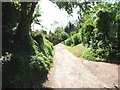
2
The Bridle Road looking north west
This is a bridge over the Crock Dumble
Image: © johnfromnotts
Taken: 24 May 2009
0.04 miles
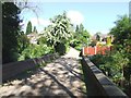
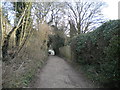
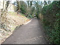
3
Bridle Road
The old horseback route to Lambley, it still retains the status of bridleway, but is not a through route for vehicles, although it provides access to substantial areas of housing. It is seen here crossing the Crock Dumble.
Image: © Alan Murray-Rust
Taken: 14 Nov 2008
0.04 miles
4
Small Stream, Burton Joyce
This looks calm and peaceful in the summer of 2008, but the overflowing of this brook contributed to the very bad floods in this area in the previous summer.
Image: © Oxymoron
Taken: 25 Jul 2008
0.05 miles
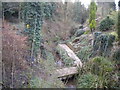
5
Burton Joyce dumble
A surprisingly deep cut section of dumble now surrounded by housing development.
For a discussion on dumbles, see https://www.geograph.org.uk/discuss/index.php?action=vthread&topic=9532
Image: © Alan Murray-Rust
Taken: 1 Jun 2021
0.05 miles
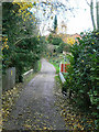
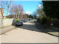
6
Bridle Road, Burton Joyce
The southernmost section of Bridle Road is a track rather than a road, and provides vehicular access only to houses along it (though it continues to be a public bridleway), despite being very much in the village. Through traffic must use Padleys Lane or Lambley Lane to descend to the village centre and the A612.
Image: © Richard Vince
Taken: 22 Feb 2014
0.06 miles
7
Crock Dumble, Burton Joyce
Looking upstream from Bridle Road.
Image: © Richard Vince
Taken: 22 Feb 2014
0.06 miles
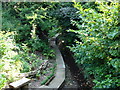
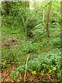
10
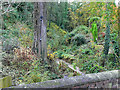
Crock Dumble
This part of the dumble is part of a private garden, and has been landscaped as semi-wilderness.
Image: © Alan Murray-Rust
Taken: 14 Nov 2008
0.07 miles