IMAGES TAKEN NEAR TO
Willow Wong, NOTTINGHAM, NG14 5FN
Introduction
This page details the photographs taken nearby to Willow Wong, NG14 5FN by members of the Geograph project.
The Geograph project started in 2005 with the aim of publishing, organising and preserving representative images for every square kilometre of Great Britain, Ireland and the Isle of Man.

There are currently over 7.5m images from over14,400 individuals and you can help contribute to the project by visiting https://www.geograph.org.uk
Image Map
Images are licensed for reuse under creativecommons.org/licenses/by-sa/2.0
Notes
- Clicking on the map will re-center to the selected point.
- The higher the marker number, the further away the image location is from the centre of the postcode.
Image Listing (17 Images Found)
Images are licensed for reuse under creativecommons.org/licenses/by-sa/2.0
Image
Details
Distance
1
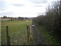
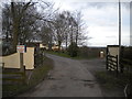
Bridleway south of Bulcote Lodge Farm
Despite its elevation up the side of the Trent valley (over sixty metres above sea level), this bridleway turned out to have retained a lot of water. In particular, the puddle visible not too far away proved challenging to pass, as the fence is surmounted with barbed wire and the hedgerow is very thorny. Thankfully, all I had to show for having negotiated it was very muddy boots and a couple of thorns in my hand.
Image: © Richard Vince
Taken: 22 Feb 2014
0.12 miles
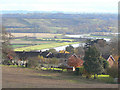
2
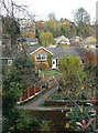
Burton Joyce and the Trent Valley
View from the footpath near Highfield Farm.
Image: © Alan Murray-Rust
Taken: 1 Jun 2021
0.14 miles
3
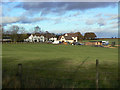
Housing to the North West of B.J.
This view was taken from Lambley Lane. Burton Joyce grew rapidly in the late 1960s when this housing development was made. It shows the typical buildings in the Padleys Lane and Foxhill area.
There are more views of Burton Joyce in the Interactive Virtual Tour at: http://www.bjtour.org.uk
Image: © johnfromnotts
Taken: 5 Jan 2009
0.14 miles
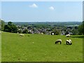
4
View over Burton Joyce
The ridge behind Burton Joyce provides a fine view down over the River Trent.
Image: © Alan Murray-Rust
Taken: 14 Nov 2008
0.20 miles
5
Crock Dumble
View across the dumble from Lambley Lane. This part of the valley has been built up with homes for Nottingham commuters. At the foot of the picture is the bridge carrying Bridle Road over the dumble stream.
Image: © Alan Murray-Rust
Taken: 14 Nov 2008
0.20 miles
6
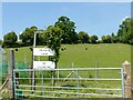
Entrance to Bulcote Lodge Farm
The signage hereabouts leaves one in no doubt as to which way the public bridleway does not go.
Image: © Richard Vince
Taken: 22 Feb 2014
0.20 miles
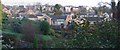
7

View from the top of Hillside Drive
Looking over the rooftops of Burton Joyce.
Image: © Alan Murray-Rust
Taken: 1 Jun 2021
0.21 miles
8
No sledging
An unlikely activity on what was the hottest day of the year to date.
Image: © Alan Murray-Rust
Taken: 1 Jun 2021
0.21 miles
9
Bulcote Lodge Farm
Now very much an equitation centre.
Image: © Alan Murray-Rust
Taken: 14 Nov 2008
0.22 miles
10
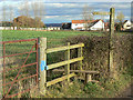
Stile and signpost
Footpath to Lambley village with Bulcote Lodge Farm beyond.
Image: © Alan Murray-Rust
Taken: 14 Nov 2008
0.22 miles