IMAGES TAKEN NEAR TO
Main Street, NOTTINGHAM, NG14 5ED
Introduction
This page details the photographs taken nearby to Main Street, NG14 5ED by members of the Geograph project.
The Geograph project started in 2005 with the aim of publishing, organising and preserving representative images for every square kilometre of Great Britain, Ireland and the Isle of Man.

There are currently over 7.5m images from over14,400 individuals and you can help contribute to the project by visiting https://www.geograph.org.uk
Image Map
Images are licensed for reuse under creativecommons.org/licenses/by-sa/2.0
Notes
- Clicking on the map will re-center to the selected point.
- The higher the marker number, the further away the image location is from the centre of the postcode.
Image Listing (105 Images Found)
Images are licensed for reuse under creativecommons.org/licenses/by-sa/2.0
Image
Details
Distance
1
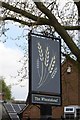
The sign of The Wheatsheaf
This is at the rear entrance off Main Street.
Image: © David Lally
Taken: 17 Apr 2017
0.02 miles
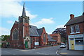
2
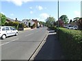
Main St. from outside the Methodist Church
Image: © johnfromnotts
Taken: 24 May 2009
0.02 miles
5
Burton Joyce Community Church, Main Street
This Methodist church has now been closed.
Image: © Bryn Holmes
Taken: 22 Mar 2019
0.06 miles
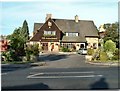
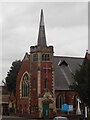
6
Burton Joyce NG14, Notts.
This, "the new Methodist Church" was built in 1908 to replace the original Wesley Chapel in nearby Willow Wong that had existed since 1823. The road sandwiched between the church and the physiotherapy clinic is Meadow Lane, the former Nottingham-Grimsby Road and for many years a private toll road. Apparently the toll-keeper's house and the gate were demolished when the new church was built.
Image: © David Hallam-Jones
Taken: 19 May 2013
0.06 miles
7
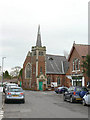
Burton Joyce Methodist Church
In the somewhat mannerist gothic style very typical of Methodist churches of the period (late 19th/early 20th centuries). The ordnance Survey clearly does not consider the spire to be worthy of the name as the map symbol is a plain cross.
Image: © Alan Murray-Rust
Taken: 14 Nov 2008
0.06 miles
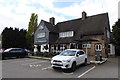
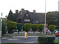
8
The Wheatsheaf
Roadhouse-style public house on Church Road
Image: © Alan Murray-Rust
Taken: 14 Nov 2008
0.06 miles
9
Wheatsheaf, Burton Joyce
1930s roadside pub, presumably built when Church Road was driven through the village in the 1930s.
Image: © Alan Murray-Rust
Taken: 16 Oct 2009
0.07 miles
10
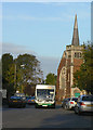
Bus to Nottingham
Passing the Methodist Church in the centre of Burton Joyce.
Image: © Alan Murray-Rust
Taken: 16 Oct 2009
0.07 miles