IMAGES TAKEN NEAR TO
Willow Close, NOTTINGHAM, NG13 9PZ
Introduction
This page details the photographs taken nearby to Willow Close, NG13 9PZ by members of the Geograph project.
The Geograph project started in 2005 with the aim of publishing, organising and preserving representative images for every square kilometre of Great Britain, Ireland and the Isle of Man.

There are currently over 7.5m images from over14,400 individuals and you can help contribute to the project by visiting https://www.geograph.org.uk
Image Map
Images are licensed for reuse under creativecommons.org/licenses/by-sa/2.0
Notes
- Clicking on the map will re-center to the selected point.
- The higher the marker number, the further away the image location is from the centre of the postcode.
Image Listing (77 Images Found)
Images are licensed for reuse under creativecommons.org/licenses/by-sa/2.0
Image
Details
Distance
1
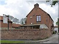
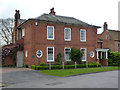
The Boot and Shoe, Granby
The layout of ancillary buildings on older maps suggests that this may have doubled as a farmhouse, a not unusual feature of early village pubs.
Image: © Alan Murray-Rust
Taken: 27 Apr 2014
0.01 miles
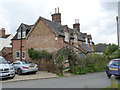
2
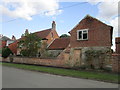
Granby Farmhouse and outbuildings
The farmhouse dates from 1762 https://historicengland.org.uk/listing/the-list/list-entry/1227718 The outbuildings in their lower storey are constructed using blue lias.
Image: © Jonathan Thacker
Taken: 13 Aug 2019
0.01 miles
3
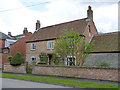
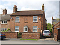
Granby Farmhouse, Church Street
The stone plaque below the small gable window is inscribed 'G H 1762'. Typical brick-built 18th century farmhouse. Listed Grade II.
Image: © Alan Murray-Rust
Taken: 27 Apr 2014
0.01 miles
4
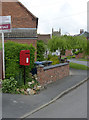
Granby postbox ref NG13 328
Standard E II R lampbox on post.
Image: © Alan Murray-Rust
Taken: 27 Apr 2014
0.01 miles
5
Newbray House, Church Street
A distinctive Victorian house with unusually wide eaves and bullseye windows.
Image: © Alan Murray-Rust
Taken: 27 Apr 2014
0.02 miles
6
Lodge Farmhouse, Church Street, Granby
Early 19th century small 3-bay farmhouse in brick with pantiled roof. Note the firemark http://www.geograph.org.uk/photo/3955487 in the blank 1st floor window bay. Listed Grade II.
Image: © Alan Murray-Rust
Taken: 27 Apr 2014
0.04 miles
7
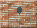
Firemark, Lodge Farmhouse, Granby
Issued by the Nottinghamshire and Derbyshire Fire and Life Assurance Co which was in business between 1835 and 1869. See http://www.geograph.org.uk/photo/3955491 for location.
Image: © Alan Murray-Rust
Taken: 27 Apr 2014
0.04 miles
8
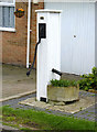
Granby Village Pump
Restored in 2002. This appears to be still in its original location. The wooden boxing is very typical of the area.
Image: © Alan Murray-Rust
Taken: 27 Apr 2014
0.05 miles
9
Hall Farm Cottages, Chapel Lane
A pair of estate cottages.
Image: © Alan Murray-Rust
Taken: 27 Apr 2014
0.05 miles
10
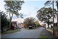
Green and bus shelter, Granby
The green is also shown at Image On the right is the churchyard.
Image: © Derek Harper
Taken: 11 Oct 2014
0.05 miles