IMAGES TAKEN NEAR TO
Main Road, NOTTINGHAM, NG13 9DA
Introduction
This page details the photographs taken nearby to Main Road, NG13 9DA by members of the Geograph project.
The Geograph project started in 2005 with the aim of publishing, organising and preserving representative images for every square kilometre of Great Britain, Ireland and the Isle of Man.

There are currently over 7.5m images from over14,400 individuals and you can help contribute to the project by visiting https://www.geograph.org.uk
Image Map
Images are licensed for reuse under creativecommons.org/licenses/by-sa/2.0
Notes
- Clicking on the map will re-center to the selected point.
- The higher the marker number, the further away the image location is from the centre of the postcode.
Image Listing (42 Images Found)
Images are licensed for reuse under creativecommons.org/licenses/by-sa/2.0
Image
Details
Distance
1
The beginning of the footpath to Car Dyke Bridge
Modern dwelling on the right.
Image: © Jonathan Thacker
Taken: 1 Apr 2011
0.02 miles
2
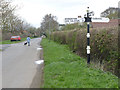
Fingerpost, Hawksworth crossroads
Notts C C traditional cast-iron with plain finial.
Image: © Alan Murray-Rust
Taken: 6 Apr 2014
0.05 miles
3
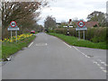
Offset crossroads, Hawksworth
A single fingerpost is placed midway between the two junctions.
Image: © Alan Murray-Rust
Taken: 6 Apr 2014
0.06 miles
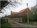
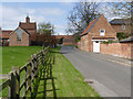
4
Top Farm, Hawksworth
Behind the largely old wall http://www.britishlistedbuildings.co.uk/en-448130-boundary-walls-at-top-farm-hawksworth stands the model farm buildings of Top Farm http://www.britishlistedbuildings.co.uk/en-448131-model-farm-buildings-at-top-farm-hawkswo, now converted to dwellings.
Image: © Jonathan Thacker
Taken: 1 Apr 2011
0.08 miles
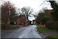
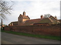
6
Town Street, Hawksworth
The building to the left with the bellcote is the former stable range of Top Farm, built as a model farm in 1837. Now converted to dwellings, Listed Grade II.
Image: © Alan Murray-Rust
Taken: 13 Apr 2014
0.11 miles
7
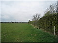
The footpath to Car Dyke Bridge
Here it passes through a field in which horses are kept. Screveton is in the distance.
Image: © Jonathan Thacker
Taken: 1 Apr 2011
0.11 miles
8
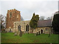
Saint Mary & All Saints Church, Hawksworth
Interesting church in the village of Hawksworth. The churchyard contains remains of dedication stone & churchyard cross.
http://www.nottshistory.org.uk/articles/summerexcursion1897/hawksworth.htm
Image: © Bob Danylec
Taken: 27 Nov 2005
0.12 miles
9
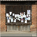
Hawksworth village notice board
An old barn door has been commandeered for the purpose.
Image: © Alan Murray-Rust
Taken: 13 Apr 2014
0.12 miles
10
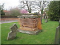
All trussed up
A tomb in the churchyard at Hawksworth. Gaps in the masonry have been filled with plywood but now the whole thing is bound together with plastic mesh.
Image: © Jonathan Thacker
Taken: 1 Apr 2011
0.12 miles