IMAGES TAKEN NEAR TO
Brunts Lane, NOTTINGHAM, NG13 8NQ
Introduction
This page details the photographs taken nearby to Brunts Lane, NG13 8NQ by members of the Geograph project.
The Geograph project started in 2005 with the aim of publishing, organising and preserving representative images for every square kilometre of Great Britain, Ireland and the Isle of Man.

There are currently over 7.5m images from over14,400 individuals and you can help contribute to the project by visiting https://www.geograph.org.uk
Image Map
Images are licensed for reuse under creativecommons.org/licenses/by-sa/2.0
Notes
- Clicking on the map will re-center to the selected point.
- The higher the marker number, the further away the image location is from the centre of the postcode.
Image Listing (37 Images Found)
Images are licensed for reuse under creativecommons.org/licenses/by-sa/2.0
Image
Details
Distance
1
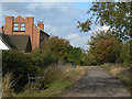
Brunts Lane
A restricted byway which links East Bridgford with the A6097. The restriction on use by motor vehicles seems to be reasonably well observed.
Image: © Alan Murray-Rust
Taken: 23 Oct 2009
0.02 miles
2
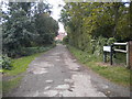
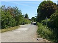
North end of Brunts Lane, East Bridgford
A restricted byway, hence the poor surface.
Image: © Richard Vince
Taken: 15 Oct 2016
0.06 miles
3
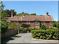
Walnut Lodge, East Bridgford
Former farmhouse, dating back to the early 18th century, with later additions. Listed Grade II.
Image: © Alan Murray-Rust
Taken: 29 May 2020
0.08 miles
5

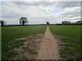
Public footpath off Walnut Tree Lane, East Bridgford
Image: © Richard Vince
Taken: 15 Oct 2016
0.10 miles
6
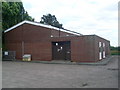
East Bridgford Telephone Exchange, Notts
Situated in Springdale Lane, this redbrick TE replaced the TE in Butt Lane sometime during the 1970s, SK7042 refers http://www.geograph.org.uk/photo/1620016. Besides East Bridgford, this TE also serves Car Colston, Newton and Screveton nearby. It has (01949) 20xxx, 21xxx numbers and its postcode is NG13 8NP.
Image: © David Hillas
Taken: 10 Jul 2010
0.10 miles

9
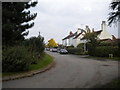
Springdale Lane, East Bridgford
Restricted byway running from the village to the Fosse Way. One of three parallel lanes, of which only one is a full highway.
Image: © Alan Murray-Rust
Taken: 29 May 2020
0.11 miles
10
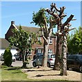
Tree surgery, East Bridgford
Not the prettiest of results; difficult to see how the trees will recover.
Image: © Alan Murray-Rust
Taken: 29 May 2020
0.13 miles