IMAGES TAKEN NEAR TO
Fosse Way, NOTTINGHAM, NG13 8LB
Introduction
This page details the photographs taken nearby to Fosse Way, NG13 8LB by members of the Geograph project.
The Geograph project started in 2005 with the aim of publishing, organising and preserving representative images for every square kilometre of Great Britain, Ireland and the Isle of Man.

There are currently over 7.5m images from over14,400 individuals and you can help contribute to the project by visiting https://www.geograph.org.uk
Image Map
Images are licensed for reuse under creativecommons.org/licenses/by-sa/2.0
Notes
- Clicking on the map will re-center to the selected point.
- The higher the marker number, the further away the image location is from the centre of the postcode.
Image Listing (37 Images Found)
Images are licensed for reuse under creativecommons.org/licenses/by-sa/2.0
Image
Details
Distance
1
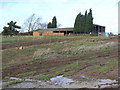
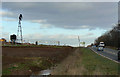
Fosse Farm
Much of the farm has already been demolished, and presumably these buildings are also effectively derelict as there will be no access when the new road is open.
Image: © Alan Murray-Rust
Taken: 6 Dec 2009
0.04 miles
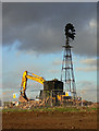
2
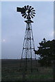
Fosse Farm windpump (A46 near Kneeton): 2015
For photos of the pump in 2009 see Image and Image Alan Murray-Rust's wish that the pump be preserved during reconstruction of the A46 (and demolition of the farmhouse) has been granted, but the pump has been moved to the nearest corner of the post and rail enclosure shown in Image
Image: © Chris
Taken: 18 Mar 2015
0.04 miles
3
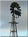
Windpump at Fosse Farm
Close-up of the top of the pump. The back vane has been sprung round 90 degrees so that the sails do not catch the wind.
Image: © Alan Murray-Rust
Taken: 6 Dec 2009
0.05 miles
4
Windpump at Fosse Farm
Various surrounding buildings, including the farmhouse, have been demolished but at this stage the windpump survives. It would be nice to think that it could be dismantled and re-erected as there are now so few survivors.
Image: © Alan Murray-Rust
Taken: 6 Dec 2009
0.05 miles
5
Fosse Farm windpump
I was delighted to find that following my earlier apprehension http://www.geograph.org.uk/photo/1611623 the windpump has been resited following the reconstruction of the A46
Image: © Alan Murray-Rust
Taken: 5 Aug 2012
0.05 miles
6
Windpump at Fosse Farm
Various surrounding buildings, including the farmhouse, have been demolished but at this stage the windpump survives. It would be nice to think that it could be dismantled and re-erected as there are now so few survivors.
Image: © Alan Murray-Rust
Taken: 6 Dec 2009
0.06 miles
7

Windpump at Fosse Farm
Close-up of the top of the pump. The back vane has been sprung round 90 degrees so that the sails do not catch the wind. The pump appears to have been painted black at some stage, and stands out in silhouette.
Image: © Alan Murray-Rust
Taken: 6 Dec 2009
0.06 miles
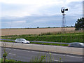
8
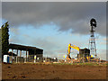
A46 at Fosse Farm
Showing the old windpump, a rare survivor, which sadly stands in the middle of the new alignment of the A46. The farmhouse used to stand between the pump and the main road.
Image: © Alan Murray-Rust
Taken: 6 Dec 2009
0.09 miles
9
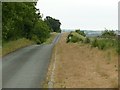
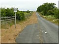
Farm track and bridleway near Car Colston
This is the former A46 roadway – Fosse Way.
The tarmacked section is the southbound lane of the old roadway, the northbound lane being covered with soil to make it more suitable for horses. The new A46 is to the right of the fence.
Image: © Alan Murray-Rust
Taken: 7 Jun 2020
0.09 miles
10
Farm track and bridleway near Car Colston
This is the former A46 roadway – Fosse Way. The tarmacked section is the southbound lane of the old roadway, the northbound lane being covered with soil to make it more suitable for horses, with a few sections left bare as passing places. Just visible are the remains of a white arrow from the old road surface. The new A46 is to the left of the fence.
The parched nature of the bridleway side is the result of two months with very little rain where the old tarmac is only thinly covered.
Image: © Alan Murray-Rust
Taken: 7 Jun 2020
0.11 miles