IMAGES TAKEN NEAR TO
Redmile, NOTTINGHAM, NG13 0GS
Introduction
This page details the photographs taken nearby to NG13 0GS by members of the Geograph project.
The Geograph project started in 2005 with the aim of publishing, organising and preserving representative images for every square kilometre of Great Britain, Ireland and the Isle of Man.

There are currently over 7.5m images from over14,400 individuals and you can help contribute to the project by visiting https://www.geograph.org.uk
Image Map
Images are licensed for reuse under creativecommons.org/licenses/by-sa/2.0
Notes
- Clicking on the map will re-center to the selected point.
- The higher the marker number, the further away the image location is from the centre of the postcode.
Image Listing (9 Images Found)
Images are licensed for reuse under creativecommons.org/licenses/by-sa/2.0
Image
Details
Distance
1
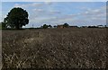
Old Hill Farm across the fields
In the Vale of Belvoir, north-east Leicestershire.
Image: © Mat Fascione
Taken: 14 Sep 2008
0.02 miles
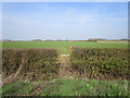
3
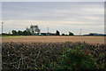
Vale of Belvoir farmland
Standing in Nottinghamshire and looking into Leicestershire. The county boundary follows the hedge line across this square. Old Hill Farm is half in the featured square and half in Image
Image: © Kate Jewell
Taken: 27 Oct 2006
0.09 miles
4
Old Hill Farm
In the Vale of Belvoir, north-east Leicestershire.
Image: © Mat Fascione
Taken: 14 Sep 2008
0.10 miles
5
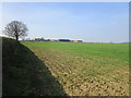
Footpath to Bottesford
The path begins with a somewhat overgrown stile. The path beyond it is through a cultivated field. However, just to the right of this picture is a wide farm gate which leads directly to a wide uncultivated but maintained field edge. A diversion of the footpath to the field edge would probably please both farmer and walker.
Image: © Jonathan Thacker
Taken: 30 Mar 2019
0.15 miles
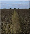
6
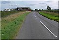
Footpath to Bottesford
The footpath travels a couple of meandering miles to the village of Bottesford.
Image: © Mat Fascione
Taken: 14 Sep 2008
0.15 miles
7
Footpath to Bottesford
The footpath travels a couple of meandering miles across the Vale of Belvoir in northeast Leicestershire.
Image: © Mat Fascione
Taken: 14 Sep 2008
0.19 miles
8
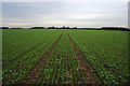
Footpath from Glebe Farm to Bottesford
The footpath goes straight across the middle of this field. The crop is winter wheat. It looks as if broad beans had been grown during the summer; there are lots of young bean plants growing as well. These plants were wilting seriously on the far side of the field so I presumed a selective weed killer had been applied. Compare to Image taken three fields to the east just over a year ago.
Image: © Kate Jewell
Taken: 27 Oct 2006
0.20 miles
9
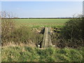
Simple footbridge
Of fairly recent construction but not on a public footpath. Easy access for game shoots?
Image: © Jonathan Thacker
Taken: 30 Mar 2019
0.24 miles