IMAGES TAKEN NEAR TO
Granary Close, NOTTINGHAM, NG13 0FS
Introduction
This page details the photographs taken nearby to Granary Close, NG13 0FS by members of the Geograph project.
The Geograph project started in 2005 with the aim of publishing, organising and preserving representative images for every square kilometre of Great Britain, Ireland and the Isle of Man.

There are currently over 7.5m images from over14,400 individuals and you can help contribute to the project by visiting https://www.geograph.org.uk
Image Map
Images are licensed for reuse under creativecommons.org/licenses/by-sa/2.0
Notes
- Clicking on the map will re-center to the selected point.
- The higher the marker number, the further away the image location is from the centre of the postcode.
Image Listing (259 Images Found)
Images are licensed for reuse under creativecommons.org/licenses/by-sa/2.0
Image
Details
Distance
1
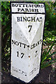
Bottesford Parish Milepost
The cast iron mile post gives distances to Bingham (7 miles), Nottingham (17 miles) and Grantham (7 miles). It was erected when the main road through Bottesford was a turnpike. With both the Grantham Canal and the railway offering alternatives, wagon traffic had declined by the latter half of the 19th century and the road was de-turnpiked in 1876. Of course, traffic levels were to build up again on what became the A52 and the village eventually got a by-pass in 1989. See also Image
Image: © Stephen McKay
Taken: 17 May 2022
0.01 miles
2
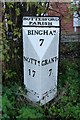
Old Milepost by the former A52, Grantham Road, Bottesford
Cast iron post by the UC road (was A52), in parish of BOTTESFORD (MELTON District), Grantham Road, opposite Wyggeston Road, on the verge, on South side of road. Boothby iron casting, erected by the Grantham & Nottingham, E division turnpike trust in the 19th century.
Inscription reads:- : NOTTM. / 17 : : BOTTESFORD / PARISH / BINGHAM / 7 : : GRANTM. / 7 : : BOOTHBY & CO / NOTTINGHAM :
Milestone Society National ID: LE_NTGT17.
Image: © J Higgins
Taken: 1 Nov 2004
0.01 miles
3
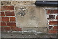
Benchmark on barn conversion on Grantham Road
Ordnance Survey cut mark benchmark described on the Bench Mark Database at www.bench-marks.org.uk/bm108656
Image: © Roger Templeman
Taken: 7 May 2019
0.05 miles
4
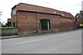
Barn conversion on the south side of Grantham Road
There is an OS benchmark Image on a stone at the left hand side of the window arch
Image: © Roger Templeman
Taken: 7 May 2019
0.05 miles
5
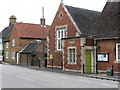
Bottesford - Fuller Room
On Grantham Road.
Image: © Dave Bevis
Taken: 15 Jun 2011
0.06 miles
6
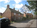
Church Street, Bottesford
Minor eighteenth century cottages.
Image: © Jonathan Thacker
Taken: 10 Apr 2012
0.07 miles
7
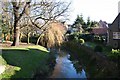
River Devon
View from Fleming's Bridge http://www.geograph.org.uk/photo/633367
Image: © Richard Croft
Taken: 13 Dec 2007
0.07 miles
9
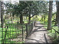
Church path
Path to Fleming's Bridge from St.Mary's church
Image: © Richard Croft
Taken: 13 Dec 2007
0.07 miles
10
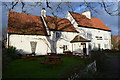
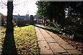
Footpath by the churchyard, Bottesford
The River Devon to the right.
Image: © Jonathan Thacker
Taken: 10 Apr 2012
0.07 miles