IMAGES TAKEN NEAR TO
Challands Drive, NOTTINGHAM, NG13 0EZ
Introduction
This page details the photographs taken nearby to Challands Drive, NG13 0EZ by members of the Geograph project.
The Geograph project started in 2005 with the aim of publishing, organising and preserving representative images for every square kilometre of Great Britain, Ireland and the Isle of Man.

There are currently over 7.5m images from over14,400 individuals and you can help contribute to the project by visiting https://www.geograph.org.uk
Image Map
Images are licensed for reuse under creativecommons.org/licenses/by-sa/2.0
Notes
- Clicking on the map will re-center to the selected point.
- The higher the marker number, the further away the image location is from the centre of the postcode.
Image Listing (70 Images Found)
Images are licensed for reuse under creativecommons.org/licenses/by-sa/2.0
Image
Details
Distance
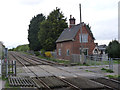
4
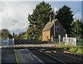
Railway route west from Bottesford
The rail route from Grantham passes through the village at Bottesford on its way to Nottingham. The end of the platform used to travel that way is in the foreground, before the level crossing.
Image: © Trevor Littlewood
Taken: 9 Nov 2022
0.10 miles
5
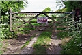
Bridleway to Beacon Hill
Leicestershire County Council has chosen to be very precise here about the distance to the end of the bridleway.
Image: © Stephen McKay
Taken: 17 May 2022
0.10 miles
7
Crossing cottage, Bottesford
The crossing is an agricultural occupation crossing, with public footpath and bridleway.
Image: © Alan Murray-Rust
Taken: 6 Apr 2014
0.11 miles
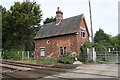
8
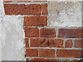
Ordnance Survey Cut Mark
This can be found on the wall of the railway crossing house at Bottesford Station.
For more detail see : http://www.bench-marks.org.uk/bm34656
Image: © Peter Wood
Taken: 4 Mar 2014
0.11 miles
9
House at level crossing west of Bottesford station
There is an Ordnance Survey cut mark benchmark www.bench-marks.org.uk/bm34656 at the far right hand corner of the building. The mark is no longer visible because of a mass of brambles growing around the corner.
Image: © Roger Templeman
Taken: 7 May 2019
0.11 miles
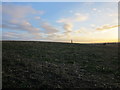
10
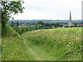
Bottesford - bridleway from Beacon Hill to Station Road
For an autumnal view of a similar scene, please see Image
Image: © Dave Bevis
Taken: 15 Jun 2011
0.12 miles