IMAGES TAKEN NEAR TO
School View, NOTTINGHAM, NG13 0EW
Introduction
This page details the photographs taken nearby to School View, NG13 0EW by members of the Geograph project.
The Geograph project started in 2005 with the aim of publishing, organising and preserving representative images for every square kilometre of Great Britain, Ireland and the Isle of Man.

There are currently over 7.5m images from over14,400 individuals and you can help contribute to the project by visiting https://www.geograph.org.uk
Image Map
Images are licensed for reuse under creativecommons.org/licenses/by-sa/2.0
Notes
- Clicking on the map will re-center to the selected point.
- The higher the marker number, the further away the image location is from the centre of the postcode.
Image Listing (11 Images Found)
Images are licensed for reuse under creativecommons.org/licenses/by-sa/2.0
Image
Details
Distance
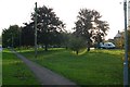
2

Autumn along Belvoir Road
In the Leicestershire village of Bottesford.
Image: © Mat Fascione
Taken: 12 Oct 2008
0.16 miles
3
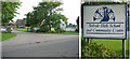
Belvoir High School, Bottesford
This High School takes students from10+ up to the year before Key Stage 4 (GCSE). They then transfer to the Upper School in Melton, 18 miles away. It's not surprising that the catchment area is campaigning for full secondary status. Note the school emblem!
(Update Nov 2007: As part of a major reorganisation of the Melton and Vale of Belvoir education provision Belvoir High has gained approval to become a 11+ to 19 trust school.)
Image: © Kate Jewell
Taken: 11 Oct 2005
0.17 miles
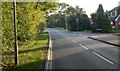
5

The village of Bottesford, Leicestershire
At 212 feet, the spire of St. Mary's Church is the highest in Leicestershire.
Image: © Mat Fascione
Taken: 12 Oct 2008
0.21 miles
6
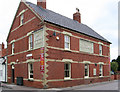
Bottesford - The Rutland Arms
On High Street.
Image: © Dave Bevis
Taken: 15 Jun 2011
0.23 miles
7

Market Street in Bottesford
At 212 feet, the spire of St. Mary's Church is the highest in Leicestershire.
Image: © Mat Fascione
Taken: 12 Oct 2008
0.23 miles
8
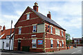
The Rutland Arms, Bottesford
This pub on High Street takes its name from the occupants of nearby Belvoir Castle. It incorporates an Indian restaurant.
Image: © Stephen McKay
Taken: 17 May 2022
0.23 miles
9
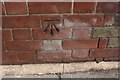
Benchmark on the Rutland Arms
Ordnance Survey cut mark benchmark described on the Bench Mark Database at www.bench-marks.org.uk/bm69106
Image: © Roger Templeman
Taken: 7 May 2019
0.23 miles
10
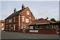
the Rutland Arms, High Street
There is an OS benchmark Image on the near corner, road face, of the pub.
Image: © Roger Templeman
Taken: 7 May 2019
0.23 miles