IMAGES TAKEN NEAR TO
Devon Lane, NOTTINGHAM, NG13 0BZ
Introduction
This page details the photographs taken nearby to Devon Lane, NG13 0BZ by members of the Geograph project.
The Geograph project started in 2005 with the aim of publishing, organising and preserving representative images for every square kilometre of Great Britain, Ireland and the Isle of Man.

There are currently over 7.5m images from over14,400 individuals and you can help contribute to the project by visiting https://www.geograph.org.uk
Image Map
Images are licensed for reuse under creativecommons.org/licenses/by-sa/2.0
Notes
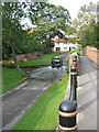
- Clicking on the map will re-center to the selected point.
- The higher the marker number, the further away the image location is from the centre of the postcode.
Image Listing (243 Images Found)
Images are licensed for reuse under creativecommons.org/licenses/by-sa/2.0
Image
Details
Distance
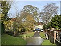
1
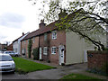
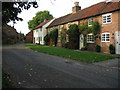
Cottages on Devon Lane
The second building displays the local tradition of Flemish bond picked out in alternating light and dark bricks.
Image: © Alan Murray-Rust
Taken: 6 Apr 2014
0.02 miles
2
Bottesford - Devon Lane footbridge
For an alternative view, please see Richard Croft's Image
Image: © Dave Bevis
Taken: 15 Jun 2011
0.02 miles
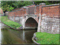
3
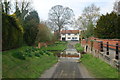
Devon Lane ford
Of particular note is the unusually elaborate pedestrian bridge, built in the early 19th century and Listed Grade II.
Image: © Alan Murray-Rust
Taken: 6 Apr 2014
0.02 miles
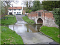
4
Devon Road Ford
Another visit to the Devon Road ford in Bottesford. More rain has brought the levels in the Devon to flood levels.
Image: © John Walton
Taken: 21 Dec 2019
0.02 miles
5
Devon Lane Ford
Here is another image of the ford on the River Devon at Bottesford. Images from previous visits can be viewed at:
https://www.geograph.org.uk/photo/6348778
https://www.geograph.org.uk/photo/1827149
Image: © John Walton
Taken: 27 Nov 2022
0.02 miles
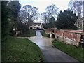
6
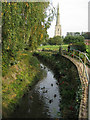
River Devon at Bottesford
The river passes through the north side of the village and in front of the church (St Mary the Virgin)
Taken from the footbridge over the ford in Image
Image: © Kate Jewell
Taken: 11 Oct 2005
0.03 miles
7
Bottesford Methodist Church
Built 1820 as a Primitive Methodist Chapel, and presumably chosen to house the merged congregation when the Chapel Lane chapel ceased to be used. The word Primitive in the datestone has not been picked out in black.
Image: © Alan Murray-Rust
Taken: 6 Apr 2014
0.03 miles
8
Ford on Devon Lane
A deep ford through the River Devon which smaller cars are recommended not to go through, especially after heavy rain.
Image: © Kate Jewell
Taken: 11 Oct 2005
0.04 miles
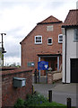
9
Devon Lane, Bottesford
Older property is concentrated to the north of the village centre
Image: © Kate Jewell
Taken: 11 Oct 2005
0.04 miles
10
River Devon Ford at Bottesford
This ford is on Devon Lane which joins shortly with the main road out of Bottesford towards Long Bennington. There is also a ford on the main road adjacent to the Church of St. Mary the Virgin with its 210 foot spire.
http://www.geograph.org.uk/photo/1828380
Image: © John Walton
Taken: 18 Apr 2010
0.04 miles