IMAGES TAKEN NEAR TO
Flying Horse Walk, NOTTINGHAM, NG1 2HN
Introduction
This page details the photographs taken nearby to Flying Horse Walk, NG1 2HN by members of the Geograph project.
The Geograph project started in 2005 with the aim of publishing, organising and preserving representative images for every square kilometre of Great Britain, Ireland and the Isle of Man.

There are currently over 7.5m images from over14,400 individuals and you can help contribute to the project by visiting https://www.geograph.org.uk
Image Map
Images are licensed for reuse under creativecommons.org/licenses/by-sa/2.0
Notes
- Clicking on the map will re-center to the selected point.
- The higher the marker number, the further away the image location is from the centre of the postcode.
Image Listing (2377 Images Found)
Images are licensed for reuse under creativecommons.org/licenses/by-sa/2.0
Image
Details
Distance
1
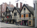
Former Flying Horse Hotel, Poultry, Nottingham
Not as old as it looks or pretends to be. The three nearest gables are original, beyond that all is C19th, but everything was given a make-over by D.G. Millet, 1936, for Trust Houses. A date of 1483 appears, but in fact very little is earlier than C18th. Grade II listed.
Now shops.
Image: © Stephen Richards
Taken: 17 Jun 2012
0.01 miles
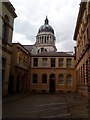
2
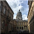
St Peter's Chambers and the Council House dome
From St Peter's Street
Image: © David Lally
Taken: 1 Jun 2017
0.01 miles
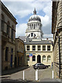
3
Italianate Nottingham
Looking towards the Council House from St Peter's Gate. I took a comparable picture in 2017, whose caption has more about the buildings either side of Bank Place: Image
Image: © John Sutton
Taken: 21 Mar 2023
0.01 miles
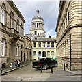
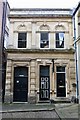
4
Bank Place
Victorian court off St Peter's Gate, with the Council House tower. The building to the left is the former waterworks office, later a bank, and on the right the former County Court. Both are now mixed retail/office use.
Image: © Alan Murray-Rust
Taken: 17 Jun 2008
0.01 miles
5
Bank Place, St. Peter's Gate, Nottingham
Image: © Andrew Abbott
Taken: 12 Jun 2010
0.02 miles
6
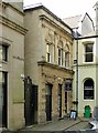
Offices, Bank Place, Nottingham
Built c.1870 in Italianate style, later forming part of the Flying Horse Hotel, now retail premises. Listed Grade II.
Image: © Alan Murray-Rust
Taken: 1 Apr 2019
0.02 miles
7
George Hallam and Sons Offices
Grade II listed. Listing number 1246250. Part of hotel, now office building. c1870, restored and altered c1989.
Image: © Andrew Abbott
Taken: 11 Feb 2018
0.02 miles
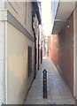
8
Nottingham, NG1 (Peck Lane)
This is the St Peter's Church end of Peck Lane, with South Parade (off Old Market Square) behind the photographer. It seems probable that this thoroughfare have carried a lot of traffic in medieval times. In 1414 it was known as Plumptre Lane although by 1504 it was being referred to as Peck Lane (perhaps after "The Peacock", a local pub). A stream - it seems - used to run down it in the direction of St. Peter's Square.
Image: © David Hallam-Jones
Taken: 24 Jun 2012
0.02 miles
9
Nottingham, NG1 (Peck Lane)
This is Peck Lane, as seen from South Parade (off Old Market Square), a thoroughfare that would have carried a lot of traffic in medieval times. In 1414 it was known as Plumptre Lane although by 1504 it was being referred to as Peck Lane (perhaps after "The Peacock", a local pub). A stream - it seems - used to run down it in the direction of St. Peter's Square. St Peter's Church can be seen in the distance.
Image: © David Hallam-Jones
Taken: 24 Jun 2012
0.02 miles
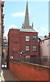
10
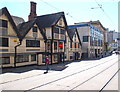
Nottingham, NG1 (South Parade)
This Grade II-listed building was once the Flying Horse Inn, established circa 1483, although by the 18th century it became "The Travellers Inn". It was extensively restored in 1935 and then survived as a public house until 1989, after which time it was converted into a shop. It is now at the entrance to the Flying Horse Walk shopping mall.
Image: © David Hallam-Jones
Taken: 24 Jun 2012
0.02 miles