IMAGES TAKEN NEAR TO
Westerdale Drive, NOTTINGHAM, NG12 5ST
Introduction
This page details the photographs taken nearby to Westerdale Drive, NG12 5ST by members of the Geograph project.
The Geograph project started in 2005 with the aim of publishing, organising and preserving representative images for every square kilometre of Great Britain, Ireland and the Isle of Man.

There are currently over 7.5m images from over14,400 individuals and you can help contribute to the project by visiting https://www.geograph.org.uk
Image Map
Images are licensed for reuse under creativecommons.org/licenses/by-sa/2.0
Notes
- Clicking on the map will re-center to the selected point.
- The higher the marker number, the further away the image location is from the centre of the postcode.
Image Listing (15 Images Found)
Images are licensed for reuse under creativecommons.org/licenses/by-sa/2.0
Image
Details
Distance
1

New housing at Nicker Hill
A large development of some 150 homes.
Image: © Alan Murray-Rust
Taken: 17 Jan 2022
0.03 miles
2
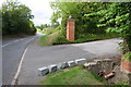
Entrance to Barnfield Farm from Nicker Hill
The culvert in the right foreground once had an Ordnance Survey benchmark on its top, but this appears to have been lost as the top stones have been lost.
Image: © Roger Templeman
Taken: 14 Sep 2018
0.11 miles
3

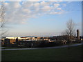
British Geological Survey, Keyworth
Recreating this 'First' for the square https://www.geograph.org.uk/photo/88573 as best as can be done. The original was taken from a location which is either not publicly accessible, or where a hedge has grown to a height which means that no photo is available.
Image: © Alan Murray-Rust
Taken: 17 Jan 2022
0.12 miles
4
British Geological Survey, Keyworth
Founded in 1835, the world's longest established national geological survey, and the UK's premier centre for earth science information and expertise. http://www.bgs.ac.uk/. The Survey headquarters moved to Keyworth in 1976.
Image: © Tim Heaton
Taken: 8 Dec 2005
0.14 miles
5
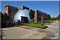
William Smith Building - British Geological Survey
Full of geologists and geoscientists, my desk is on the top floor although I'm mostly in the labs.
Image: © Ashley Dace
Taken: 24 Jul 2014
0.15 miles
6
British Geological Survey
Start of the rock walk and the gift shop.
Image: © Ashley Dace
Taken: 1 Aug 2014
0.17 miles
7
Statue of Hercules
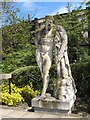
This statue is a copy of the 'Farnese Hercules', a Roman statue of 1st or 2nd century, by Charles Harriott Smith in 1851. It was carved for the Geological Museum in London from a single, 15-ton block of stone quarried at Portland in Dorset. After 20 years of public display the statue was deemed offensive to Victorian propriety, and Hercules' genitals were removed (and stored) and replaced by a fig leaf. On the removal of Hercules to Keyworth in 1977 the decision was taken to restore him to 'a complete and entire state', although he was originally hidden in an inner courtyard and inaccessible to a casual visitor. Prior to further building work in that area, Hercules was relocated to the side of the main entrance, where he is now gloriously displayed again.
Details from the Public Monument and Sculpture Association, National Recording Project.
Image: © Jonathan Wilkins
Taken: 12 May 2010
0.17 miles
8
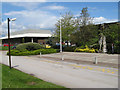
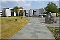
Entrance plaza, BGS
The main entrance of the headquarters building of the British Geological Survey, which was originally a religious teacher-training college. New buildings have expanded the accommodation since the time of the controversial move from London in 1977, as shown here. The statue of Hercules Image is located at the side of this small plaza.
Image: © Jonathan Wilkins
Taken: 12 May 2010
0.17 miles
9
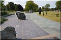
Geological walk - British Geological Survey
Several rocks - The one in the distance is some Lewissian gneiss.
Image: © Ashley Dace
Taken: 1 Aug 2014
0.19 miles
10
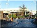
British Geological Survey, Keyworth
The main entrance to the campus.
Image: © Alan Murray-Rust
Taken: 17 Jan 2022
0.20 miles