IMAGES TAKEN NEAR TO
Brook Lane, NOTTINGHAM, NG12 5SE
Introduction
This page details the photographs taken nearby to Brook Lane, NG12 5SE by members of the Geograph project.
The Geograph project started in 2005 with the aim of publishing, organising and preserving representative images for every square kilometre of Great Britain, Ireland and the Isle of Man.

There are currently over 7.5m images from over14,400 individuals and you can help contribute to the project by visiting https://www.geograph.org.uk
Image Map
Images are licensed for reuse under creativecommons.org/licenses/by-sa/2.0
Notes
- Clicking on the map will re-center to the selected point.
- The higher the marker number, the further away the image location is from the centre of the postcode.
Image Listing (18 Images Found)
Images are licensed for reuse under creativecommons.org/licenses/by-sa/2.0
Image
Details
Distance
1
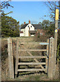
Footpath gate at Hill Farm
The gateposts have sagged so that the mechanical fastening is no longer workable, and a piece of twine has to make do instead.
Image: © Alan Murray-Rust
Taken: 20 Oct 2011
0.02 miles
2
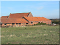
Barns at Hill Farm
A fine set of typical local brick and tile buildings which have survived the modernisation of the farm.
Image: © Alan Murray-Rust
Taken: 20 Oct 2011
0.02 miles
3
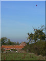
Balloon over Hill Farm
A classic day to be up in the air, with fantastic visibility.
Image: © Alan Murray-Rust
Taken: 20 Oct 2011
0.02 miles
4
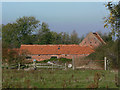
Barns at Hill Farm
A fine set of local red pantiles.
Image: © Alan Murray-Rust
Taken: 20 Oct 2011
0.02 miles
5
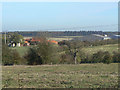
Hill Farm
An old farm which has seriously modernised and developed into the headquarters of a major animal feeds business.
Image: © Alan Murray-Rust
Taken: 20 Oct 2011
0.04 miles
6
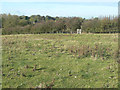
Stanton-on-the-Wolds footpath No.7
Crossing a field with traces of ridge and furrow cultivation adjacent to Hill Farm. The footpath alignment does not follow the course shown on the current 1:25000 map, although the County's map of footpaths does match.
Image: © Alan Murray-Rust
Taken: 20 Oct 2011
0.06 miles
7
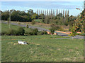
Stanton-on-the-Wolds footpath No.7
The footpath crosses the pasture below the farm house before joining the driveway where it crosses the stream.
Image: © Alan Murray-Rust
Taken: 20 Oct 2011
0.10 miles
8
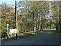
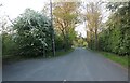
Driveway to Hill Farm
This has been planted to form an avenue. The drive also carries Stanton on the Wolds footpath No.7; the notice board on the left lists the temporary footpath closures associated with the A46 improvement works.
Image: © Alan Murray-Rust
Taken: 20 Oct 2011
0.18 miles
10
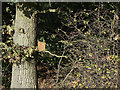
Bird box
Although much of the local attention to birds focuses on game rearing, some consideration has been given to the smaller varieties.
Image: © Alan Murray-Rust
Taken: 20 Oct 2011
0.18 miles