IMAGES TAKEN NEAR TO
Thurlby Lane, NOTTINGHAM, NG12 5RR
Introduction
This page details the photographs taken nearby to Thurlby Lane, NG12 5RR by members of the Geograph project.
The Geograph project started in 2005 with the aim of publishing, organising and preserving representative images for every square kilometre of Great Britain, Ireland and the Isle of Man.

There are currently over 7.5m images from over14,400 individuals and you can help contribute to the project by visiting https://www.geograph.org.uk
Image Map
Images are licensed for reuse under creativecommons.org/licenses/by-sa/2.0
Notes
- Clicking on the map will re-center to the selected point.
- The higher the marker number, the further away the image location is from the centre of the postcode.
Image Listing (19 Images Found)
Images are licensed for reuse under creativecommons.org/licenses/by-sa/2.0
Image
Details
Distance
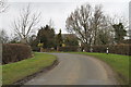

3

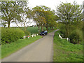
Thurlby Lane
Heading north west towards Keyworth.
Image: © JThomas
Taken: 21 Jun 2014
0.12 miles
5
Harrowed field near Widmerpool Station
The line of trees mark a farm track between Hill Farm and Queensgate Wood.
Image: © Jonathan Thacker
Taken: 29 Oct 2019
0.19 miles
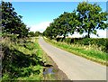
6
Farm track off Thurlby Lane
The London Underground trains in the background are being tested on the Old Dalby Test Track.
Image: © Alan Murray-Rust
Taken: 24 Jan 2014
0.21 miles
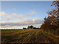
7
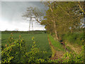
Fairham Brook
Trees on the headlands of the arable fields mark the passage of the small stream, but they are overshadowed by the parallel electricity transmission lines.
Image: © Jonathan Wilkins
Taken: 12 May 2010
0.21 miles
9

Oilseed rape crop, Hill Farm
Off Station Road.
Image: © JThomas
Taken: 21 Jun 2014
0.21 miles
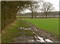
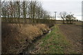
10
Stream crossing
The road up the hill to Crow Hill Farm is planted with a neat avenue of trees, which contrast with the open fields towards Keyworth. The small stream which flows south-westward is the Fairham Brook.
Image: © Jonathan Wilkins
Taken: 12 May 2010
0.21 miles