IMAGES TAKEN NEAR TO
Far Pastures Close, NOTTINGHAM, NG12 5RB
Introduction
This page details the photographs taken nearby to Far Pastures Close, NG12 5RB by members of the Geograph project.
The Geograph project started in 2005 with the aim of publishing, organising and preserving representative images for every square kilometre of Great Britain, Ireland and the Isle of Man.

There are currently over 7.5m images from over14,400 individuals and you can help contribute to the project by visiting https://www.geograph.org.uk
Image Map
Images are licensed for reuse under creativecommons.org/licenses/by-sa/2.0
Notes
- Clicking on the map will re-center to the selected point.
- The higher the marker number, the further away the image location is from the centre of the postcode.
Image Listing (84 Images Found)
Images are licensed for reuse under creativecommons.org/licenses/by-sa/2.0
Image
Details
Distance
1
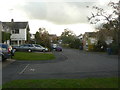
Wright's Orchard
Part of the 1970s/80s development in the south-western sector of the village.
Image: © Alan Murray-Rust
Taken: 1 Nov 2011
0.08 miles
2
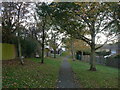
Estate footpath
The south-western corner of the village was developed in the modern idiom with pedestrian access separated as much as possible from vehicles. This path runs between Wright's Orchard and Brook View Drive.
Image: © Alan Murray-Rust
Taken: 1 Nov 2011
0.08 miles
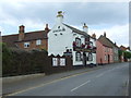
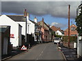
3
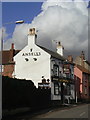
The Salutation
One of two pubs in the older part of the village, the other being The Plough http://www.geograph.org.uk/photo/1383925.
Image: © Alan Murray-Rust
Taken: 1 Nov 2011
0.09 miles
4
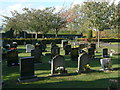
Keyworth Burial Ground
The local municipal (Parish Council) burial ground. It appears to have been established around 1960.
Image: © Alan Murray-Rust
Taken: 1 Nov 2011
0.09 miles
6
The Salutation pub, Keyworth
On Main Street.
Image: © JThomas
Taken: 21 Jun 2014
0.10 miles
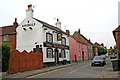
7
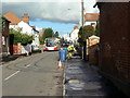
Main Street, Keyworth
A variety of activities on view. The pavement is being dressed with a new tarred surface; wheelie bins are out for collection; the bus is making its way along a tortuous route through the villages of south Nottinghamshire on its way from Newark via Bingham, Ruddington and the Queens Medical Centre to Beeston. (The route is split into three separate services, but the same bus works through, taking over 2½ hours for the complete journey).
Image: © Alan Murray-Rust
Taken: 1 Nov 2011
0.10 miles
8
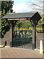
Keyworth Burial Ground
The gateway at the entrance on Wysall Lane.
Image: © Alan Murray-Rust
Taken: 1 Nov 2011
0.11 miles
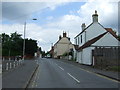
9
Main Street
The traditional part of the village which expanded enormously in the 20th century, particularly after World War II.
Image: © Alan Murray-Rust
Taken: 1 Nov 2011
0.11 miles
10
Main Street, Keyworth
Looking towards the church and The Square.
Image: © Kate Jewell
Taken: 17 Oct 2006
0.11 miles