IMAGES TAKEN NEAR TO
Thorpe-in-the-Glebe, Wysall, NOTTINGHAM, NG12 5QX
Introduction
This page details the photographs taken nearby to NG12 5QX by members of the Geograph project.
The Geograph project started in 2005 with the aim of publishing, organising and preserving representative images for every square kilometre of Great Britain, Ireland and the Isle of Man.

There are currently over 7.5m images from over14,400 individuals and you can help contribute to the project by visiting https://www.geograph.org.uk
Image Map
Images are licensed for reuse under creativecommons.org/licenses/by-sa/2.0
Notes
- Clicking on the map will re-center to the selected point.
- The higher the marker number, the further away the image location is from the centre of the postcode.
Image Listing (6 Images Found)
Images are licensed for reuse under creativecommons.org/licenses/by-sa/2.0
Image
Details
Distance
1
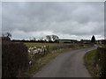
Lane from Windyridge Road, near Wysall
When I submitted the picture Image, I checked Wikipedia for a collective noun, and found "Inflation". Some time later, a perplexed viewer asked me why that was the collective noun, as he could not find it in any source.
I rechecked Wiki, to find that such a collective noun for alpacas was no longer there. My theory is that someone may have misinterpreted the "inhalation" which alpacas do when threatened. "Alpacas warn the herd about intruders by making sharp, noisy inhalations that sound like a high pitched bray".
Image: © Peter Barr
Taken: 10 Mar 2010
0.08 miles
2
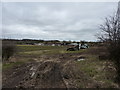
Tractor tracks
A farm which produces turf.
Image: © Peter Barr
Taken: 10 Mar 2010
0.16 miles

4
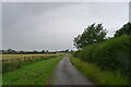
Farm track and bridleway heading towards Windyridge Road
Image: © Tim Heaton
Taken: 11 Jul 2023
0.23 miles
5
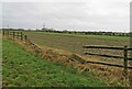
Broken fence by the driveway to Annabell's Farm
Image: © Andrew Tatlow
Taken: 14 Mar 2021
0.23 miles
6
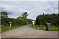
Entrance to Brooklea Farm off Windyridge Road
Image: © Ian S
Taken: 30 Aug 2020
0.23 miles