IMAGES TAKEN NEAR TO
Old Melton Road, NOTTINGHAM, NG12 5QL
Introduction
This page details the photographs taken nearby to Old Melton Road, NG12 5QL by members of the Geograph project.
The Geograph project started in 2005 with the aim of publishing, organising and preserving representative images for every square kilometre of Great Britain, Ireland and the Isle of Man.

There are currently over 7.5m images from over14,400 individuals and you can help contribute to the project by visiting https://www.geograph.org.uk
Image Map
Images are licensed for reuse under creativecommons.org/licenses/by-sa/2.0
Notes
- Clicking on the map will re-center to the selected point.
- The higher the marker number, the further away the image location is from the centre of the postcode.
Image Listing (30 Images Found)
Images are licensed for reuse under creativecommons.org/licenses/by-sa/2.0
Image
Details
Distance
1
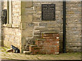
Mounting block at New Inn Manor, Widmerpool
The notice records the legend that the famous highwayman Dick Turpin rode his horse, Black Bess, up the staircase of the Manor. The bench mark shown here http://www.geograph.org.uk/photo/3825914 is just above the floodlight.
Image: © Alan Murray-Rust
Taken: 24 Jan 2014
0.00 miles
2
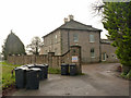
New Inn Manor House, Widmerpool
This was formerly an inn at the crossroads of the Nottingham to Melton road and the Foss Way.
Image: © Alan Murray-Rust
Taken: 24 Jan 2014
0.01 miles
3
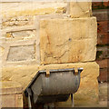
Bench mark with bolt, New Inn Manor, Widmerpool
This was a significant mark during the primary levelling of England and Wales, 1840-60, as it was mark on the Coventry to Leicester line (along the Fosse Way) where a separate line to Derby via Nottingham branched off.
The mark has suffered badly from erosion of the soft ironstone, so that the arrow has almost entirely disappeared (the end of the right hand stroke can just be distinguished) and even the datum line is now very shallow. If it had not been for the bolt, I don't think it would have been possible to recognise it as a bench mark. See http://www.geograph.org.uk/photo/3825919 and http://www.geograph.org.uk/photo/3825917 for location.
Image: © Alan Murray-Rust
Taken: 24 Jan 2014
0.01 miles
4
The former New Inn Manor, Widmerpool
This stood alongside the old alignment of the unmodernised Fosse Way, now the A46 dual carriageway. The line of wheelie bins marks the closed-off original road to Nottingham.
Image: © Alan Murray-Rust
Taken: 24 Jan 2014
0.01 miles
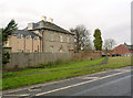
5
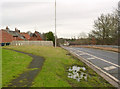
North-bound slip road at Widmerpool roundabout
Leading down from the A606 to the A46 Fosse Way. This was the site of the original cross-roads between the two roads.
Image: © Alan Murray-Rust
Taken: 24 Jan 2014
0.02 miles

8
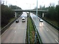
Bridge Over A46(T)
View north at the A606 junction.
Image: © Mick Garratt
Taken: 7 Jan 2006
0.07 miles
10

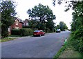
The beginning of a footpath from Melton Road to Widmerpool
Image: © Jonathan Thacker
Taken: 6 Feb 2022
0.08 miles