IMAGES TAKEN NEAR TO
Dodson Avenue, NOTTINGHAM, NG12 5QB
Introduction
This page details the photographs taken nearby to Dodson Avenue, NG12 5QB by members of the Geograph project.
The Geograph project started in 2005 with the aim of publishing, organising and preserving representative images for every square kilometre of Great Britain, Ireland and the Isle of Man.

There are currently over 7.5m images from over14,400 individuals and you can help contribute to the project by visiting https://www.geograph.org.uk
Image Map
Images are licensed for reuse under creativecommons.org/licenses/by-sa/2.0
Notes
- Clicking on the map will re-center to the selected point.
- The higher the marker number, the further away the image location is from the centre of the postcode.
Image Listing (29 Images Found)
Images are licensed for reuse under creativecommons.org/licenses/by-sa/2.0
Image
Details
Distance
1

Spinners Croft, Keyworth
A new major development of 187 homes between Platt Lane and Station Road.
Image: © Alan Murray-Rust
Taken: 17 Jan 2022
0.05 miles
2

Normanton Lane, Keyworth
Recreating this 'First' for the square https://www.geograph.org.uk/photo/235547 . I have reused the original title although most of the visible roadway is Station Road.
Image: © Alan Murray-Rust
Taken: 17 Jan 2022
0.06 miles
3

Armstrong Road, Keyworth
Part of the new Spinners Croft housing development.
Image: © Alan Murray-Rust
Taken: 17 Jan 2022
0.07 miles
4
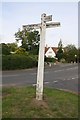
Old signpost at Nicker Hill / Normanton Lane junction
The signpost has Milestone Society National ID: NT_SK6131A
Image: © Roger Templeman
Taken: 14 Sep 2018
0.08 miles
5
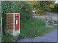
Plumtree Road postbox ref no NG12 101
E II R wall box in a purpose-built brick pillar. The formal name of the road is Station Road, although it does indeed lead to Plumtree.
Image: © Alan Murray-Rust
Taken: 1 Nov 2011
0.08 miles
6
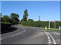
Normanton Lane, Keyworth
The road leading north, out of Keyworth, to join the A606 and thence Nottingham. The road south-east, signposted to Stanton (-on-the-Wolds) to the right
Image: © Tim Heaton
Taken: 8 Sep 2006
0.09 miles
7
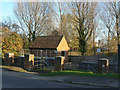
Sewage Pumping Station
On the corner of Platt Lane and Nicker Hill, serving the north eastern sector of Keyworth. Because Keyworth sits on top of a hill, the land falls away on all sides so the drainage cannot all be directed straight to the treatment works to the west of the village.
Image: © Alan Murray-Rust
Taken: 1 Nov 2011
0.09 miles
8
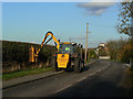
Hedging time
A traditional autumn agricultural task, although the equipment used has changed dramatically.
Image: © Alan Murray-Rust
Taken: 1 Nov 2011
0.10 miles
9
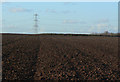
Modern ridge and furrow
The low November afternoon light shows how even modern plough techniques show how easily the ridges and furrows could develop by being repeatedly ploughed in the same pattern.
Image: © Alan Murray-Rust
Taken: 1 Nov 2011
0.10 miles
10

Pond at Spinners Croft
Created to absorb surface run-off from the new housing development.
Image: © Alan Murray-Rust
Taken: 17 Jan 2022
0.13 miles