IMAGES TAKEN NEAR TO
Main Street, NOTTINGHAM, NG12 5PY
Introduction
This page details the photographs taken nearby to Main Street, NG12 5PY by members of the Geograph project.
The Geograph project started in 2005 with the aim of publishing, organising and preserving representative images for every square kilometre of Great Britain, Ireland and the Isle of Man.

There are currently over 7.5m images from over14,400 individuals and you can help contribute to the project by visiting https://www.geograph.org.uk
Image Map
Images are licensed for reuse under creativecommons.org/licenses/by-sa/2.0
Notes
- Clicking on the map will re-center to the selected point.
- The higher the marker number, the further away the image location is from the centre of the postcode.
Image Listing (41 Images Found)
Images are licensed for reuse under creativecommons.org/licenses/by-sa/2.0
Image
Details
Distance
1
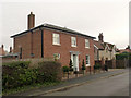
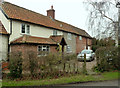
Village House, Widmerpool
Looking like an early 18th century house, but in fact a product of (probably) the 21st. The give-away is that the brickwork is entirely in stretcher bond, meaning that it is only an outer skin.
Image: © Alan Murray-Rust
Taken: 24 Jan 2014
0.02 miles
2
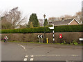
Widmerpool, fingerpost and postbox
The postbox is ref NG12 93 and is a standard EIIR lamp box.
Image: © Alan Murray-Rust
Taken: 24 Jan 2014
0.03 miles
3
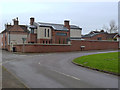
New house on Wysall Lane, Widmerpool
Built on the site of the village school (later village hall). The architectural style is a real contrast with the neighbouring Village House http://www.geograph.org.uk/photo/3826815. My preference is for the modernist version which looks perfectly at home and does not pretend to be something that it is not.
Image: © Alan Murray-Rust
Taken: 24 Jan 2014
0.03 miles
4
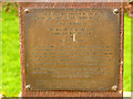
Widmerpool Village Sign dedication plate
See http://www.geograph.org.uk/photo/3828021
Image: © Alan Murray-Rust
Taken: 24 Jan 2014
0.04 miles
5
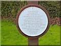
Blue plaque on Widmerpool Village sign
See http://www.geograph.org.uk/photo/3828021
Image: © Alan Murray-Rust
Taken: 24 Jan 2014
0.04 miles
6
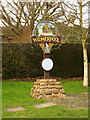
Widmerpool Village Sign
Erected in 2000 as a millennium celebration. The round plaque is shown here http://www.geograph.org.uk/photo/3828022 and details of the sign can be found on the brass plate below it http://www.geograph.org.uk/photo/3828023 . The main panel depicts the church, Widmerpool Hall, Fairham Brook and the telephone kiosk, which was apparently the earliest rural kiosk in England.
Image: © Alan Murray-Rust
Taken: 24 Jan 2014
0.04 miles
7
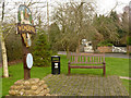
Widmerpool Village Sign and Millennium seat
On a small green in the centre of the village.
Image: © Alan Murray-Rust
Taken: 24 Jan 2014
0.04 miles
8
Smithy Farm, Widmerpool
Presumably at some stage covering both functions.
Image: © Alan Murray-Rust
Taken: 24 Jan 2014
0.05 miles
9

Main Street, Widmerpool
Seen from Field Lane.
Image: © Richard Vince
Taken: 25 Aug 2018
0.06 miles
10
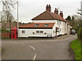
Cottages on Field Lane
The third one (by the parked cars) has the odd name 'Cat and Custard Pot Cottage'. It's not clear whether the telephone kiosk is the 'first rural kiosk in England' celebrated on the village sign http://www.geograph.org.uk/photo/3828021
Image: © Alan Murray-Rust
Taken: 24 Jan 2014
0.07 miles