IMAGES TAKEN NEAR TO
Brooklands, NOTTINGHAM, NG12 5PN
Introduction
This page details the photographs taken nearby to Brooklands, NG12 5PN by members of the Geograph project.
The Geograph project started in 2005 with the aim of publishing, organising and preserving representative images for every square kilometre of Great Britain, Ireland and the Isle of Man.

There are currently over 7.5m images from over14,400 individuals and you can help contribute to the project by visiting https://www.geograph.org.uk
Image Map
Images are licensed for reuse under creativecommons.org/licenses/by-sa/2.0
Notes
- Clicking on the map will re-center to the selected point.
- The higher the marker number, the further away the image location is from the centre of the postcode.
Image Listing (56 Images Found)
Images are licensed for reuse under creativecommons.org/licenses/by-sa/2.0
Image
Details
Distance
1
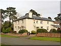
Manor Farmhouse, Widmerpool
A large early to mid 19th century house.
Image: © Alan Murray-Rust
Taken: 24 Jan 2014
0.02 miles
3
The top of Church Lane, Widmerpool
The fingerpost is an original Nottinghamshire County Council octagonal concrete post with octagonal finial.
Image: © Alan Murray-Rust
Taken: 24 Jan 2014
0.03 miles
4
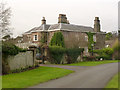
The Old Rectory, Widmerpool
Clearly the result of the living being in the grant of a wealthy landowner. A large early 19th century house with mainly rendered finish but with some dressed rubble and ashlar. Listed Grade II.
Image: © Alan Murray-Rust
Taken: 24 Jan 2014
0.04 miles

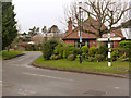
6
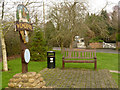
Widmerpool Village Sign and Millennium seat
On a small green in the centre of the village.
Image: © Alan Murray-Rust
Taken: 24 Jan 2014
0.07 miles
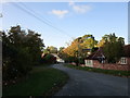
7

Wysall Lane
Heading west out of Widmerpool.
Image: © JThomas
Taken: 21 Jun 2014
0.07 miles
8
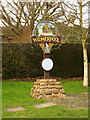
Widmerpool Village Sign
Erected in 2000 as a millennium celebration. The round plaque is shown here http://www.geograph.org.uk/photo/3828022 and details of the sign can be found on the brass plate below it http://www.geograph.org.uk/photo/3828023 . The main panel depicts the church, Widmerpool Hall, Fairham Brook and the telephone kiosk, which was apparently the earliest rural kiosk in England.
Image: © Alan Murray-Rust
Taken: 24 Jan 2014
0.08 miles
9
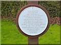
Blue plaque on Widmerpool Village sign
See http://www.geograph.org.uk/photo/3828021
Image: © Alan Murray-Rust
Taken: 24 Jan 2014
0.08 miles
10
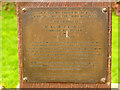
Widmerpool Village Sign dedication plate
See http://www.geograph.org.uk/photo/3828021
Image: © Alan Murray-Rust
Taken: 24 Jan 2014
0.08 miles