IMAGES TAKEN NEAR TO
Chapel Yard, NOTTINGHAM, NG12 5NJ
Introduction
This page details the photographs taken nearby to Chapel Yard, NG12 5NJ by members of the Geograph project.
The Geograph project started in 2005 with the aim of publishing, organising and preserving representative images for every square kilometre of Great Britain, Ireland and the Isle of Man.

There are currently over 7.5m images from over14,400 individuals and you can help contribute to the project by visiting https://www.geograph.org.uk
Image Map
Images are licensed for reuse under creativecommons.org/licenses/by-sa/2.0
Notes
- Clicking on the map will re-center to the selected point.
- The higher the marker number, the further away the image location is from the centre of the postcode.
Image Listing (64 Images Found)
Images are licensed for reuse under creativecommons.org/licenses/by-sa/2.0
Image
Details
Distance
1
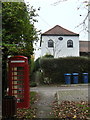
Normanton Methodist Chapel
Built in 1827, and now converted to residential accommodation, it was the only religious establishment in the village. The Anglican communion went to neighbouring Plumtree.
The K6 telephone kiosk is no longer functioning as such, but serves as a book-share depository.
Image: © Alan Murray-Rust
Taken: 11 Nov 2011
0.03 miles
2
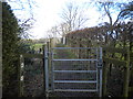
Public footpath north of Normanton (1)
Image: © Richard Vince
Taken: 27 Feb 2015
0.03 miles
3
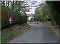
Junction on Old Melton Road, Normanton
The lane on the right carries a public footpath as well as providing vehicular access to dwellings.
Image: © Richard Vince
Taken: 27 Feb 2015
0.03 miles
4
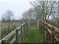
Footpath towards Cotgrave
Currently cut short by closure of a footbridge http://www.geograph.org.uk/photo/2696452. The fences are relatively recent, as they do not appear on satellite images.
Image: © Alan Murray-Rust
Taken: 11 Nov 2011
0.03 miles
5
Public footpath north of Normanton (2)
Image: © Richard Vince
Taken: 27 Feb 2015
0.03 miles
6

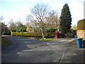
Old Melton Road, Normanton
A sharp bend on the old main road through the village.
Image: © Alan Murray-Rust
Taken: 11 Nov 2011
0.04 miles
7
Old Melton Road, Normanton
The 30 mph repeater sign is necessary because there is no street lighting through the village.
Image: © Alan Murray-Rust
Taken: 11 Nov 2011
0.04 miles
8
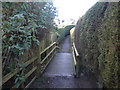
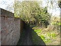
Public footpath north of Normanton (3)
The footbridge in the foreground carries the footpath across a stream that is hidden somewhere beneath the hedges.
Image: © Richard Vince
Taken: 27 Feb 2015
0.04 miles
9
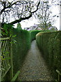
Hedged footpath
This follows the line of an established footpath to Plumtree, but has been swallowed up in suburban development.
Image: © Alan Murray-Rust
Taken: 11 Nov 2011
0.06 miles
10
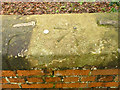
Rivet bench mark, Normanton bridge
This is likely to be the mark listed for this location on the Widmerpool to Derby survey line used during the primary levelling of England and Wales, 1840-60. See http://www.geograph.org.uk/photo/3825907 for location. (The 50p coin was placed to give an idea of the substantial size of the arrow.)
Image: © Alan Murray-Rust
Taken: 24 Jan 2014
0.06 miles