IMAGES TAKEN NEAR TO
Church Lane, NOTTINGHAM, NG12 5NE
Introduction
This page details the photographs taken nearby to Church Lane, NG12 5NE by members of the Geograph project.
The Geograph project started in 2005 with the aim of publishing, organising and preserving representative images for every square kilometre of Great Britain, Ireland and the Isle of Man.

There are currently over 7.5m images from over14,400 individuals and you can help contribute to the project by visiting https://www.geograph.org.uk
Image Map
Images are licensed for reuse under creativecommons.org/licenses/by-sa/2.0
Notes
- Clicking on the map will re-center to the selected point.
- The higher the marker number, the further away the image location is from the centre of the postcode.
Image Listing (132 Images Found)
Images are licensed for reuse under creativecommons.org/licenses/by-sa/2.0
Image
Details
Distance
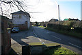
1
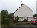
1-4 The Green
A terrace of 19th century cottages on Church Lane.
Image: © Alan Murray-Rust
Taken: 11 Nov 2011
0.01 miles
2
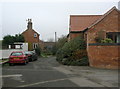
Church Lane
This was the single 'back street' of the old village.
Image: © Alan Murray-Rust
Taken: 11 Nov 2011
0.01 miles
3
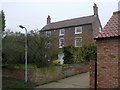
Manor Farmhouse, Plumtree
Attractive early 19th century farmhouse in red brick. Listed Grade II.
Image: © Alan Murray-Rust
Taken: 11 Nov 2011
0.03 miles
4
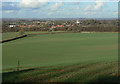
View across the Trent Valley
At the point where the footpath from Crossdale Drive to Plumtree breaks out of the built up area at the edge of the wold on which Keyworth lies. Plumtree village and church are prominent in the middle distance.
Image: © Alan Murray-Rust
Taken: 1 Nov 2011
0.04 miles
5
Church Hill, Plumtree
Looking down the street towards Station Road from the corner of the elevated churchyard.
Image: © Kate Jewell
Taken: 24 Jan 2008
0.04 miles
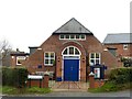
6
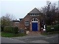
Burnside Hall, Plumtree
This was donated to the village by Alice Burnside in memory of her husband and opened in 1921. The Burnside family was prominent in the village, including the rector who built the Old Rectory in the early 19th century. The hall acts as a meeting place for the village and currently also houses a playschool.
Image: © Alan Murray-Rust
Taken: 11 Nov 2011
0.05 miles
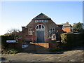
8
Burnside Memorial Hall, Plumtree
An update to my 2011 view https://www.geograph.org.uk/photo/2696510 . New flank walls to the gateway, a new notice board and the removal of the tree.
Image: © Alan Murray-Rust
Taken: 23 Jan 2022
0.05 miles
9
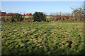
Public footpath off Church Hill
The footpath crosses this small pasture before cutting across a much larger field on its way to meet the footpath from Main Street to Tollerton beyond.
Image: © Kate Jewell
Taken: 24 Jan 2008
0.05 miles
10
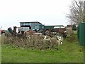
The remains of Manor Farm farmyard
No longer attached to the original farm, behind the fence to the right, where the outbuildings have been converted to residential use. The separate passage of the footpath appears to be a quite recent (c.2015) development.
Image: © Alan Murray-Rust
Taken: 23 Jan 2022
0.06 miles