IMAGES TAKEN NEAR TO
Station Road, NOTTINGHAM, NG12 5NA
Introduction
This page details the photographs taken nearby to Station Road, NG12 5NA by members of the Geograph project.
The Geograph project started in 2005 with the aim of publishing, organising and preserving representative images for every square kilometre of Great Britain, Ireland and the Isle of Man.

There are currently over 7.5m images from over14,400 individuals and you can help contribute to the project by visiting https://www.geograph.org.uk
Image Map
Images are licensed for reuse under creativecommons.org/licenses/by-sa/2.0
Notes
- Clicking on the map will re-center to the selected point.
- The higher the marker number, the further away the image location is from the centre of the postcode.
Image Listing (136 Images Found)
Images are licensed for reuse under creativecommons.org/licenses/by-sa/2.0
Image
Details
Distance
1
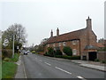
Poplar Farmhouse
Now purely residential, the farm having closed a few years back.
Image: © Alan Murray-Rust
Taken: 11 Nov 2011
0.00 miles
2
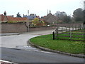
The Poplars
Development of private houses on the old Poplar Farm farmyard.
Image: © Alan Murray-Rust
Taken: 11 Nov 2011
0.03 miles
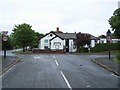
3
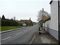
Station Road, Plumtree
The village enjoys a good bus service into Nottingham with generally 5 buses per hour during the daytime.
Image: © Alan Murray-Rust
Taken: 11 Nov 2011
0.04 miles
4
The Poplars
Development of large private houses on the old Poplar Farm farmyard. Note the ridge and furrow strips in the field.
Image: © Alan Murray-Rust
Taken: 11 Nov 2011
0.05 miles
5

Footpath near Plumtree
Part of the Notts Wolds Way long distance path.
Image: © Alan Murray-Rust
Taken: 23 Jan 2022
0.07 miles
6
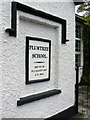
Plumtree School, commemorative plaque
Inscribed plaque commemorating its founding in 1840 by one of the main local landowners.
Image: © Alan Murray-Rust
Taken: 11 Nov 2011
0.07 miles
7
Plumtree Telephone Exchange
This dates from the 1960s and, as it is far larger than the needs of the village, presumably caters for Keyworth and Tollerton as well.
Image: © Alan Murray-Rust
Taken: 11 Nov 2011
0.07 miles
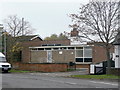
8
Plumtree School
An independent Primary School
Image: © Geoff Pick
Taken: 3 Jul 2009
0.07 miles
9
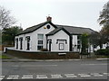
Plumtree School
Built in 1840 http://www.geograph.org.uk/photo/2696102, it became a Church of England Controlled School in 1951 until closure in 1974. More recently it has become a privately run primary school.
Image: © Alan Murray-Rust
Taken: 11 Nov 2011
0.07 miles
10
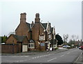
The Griffin at Plumtree
A large Victorian public house of 1843, doubtless erected at the expense of the local landowner. It originally had a farm attached which would probably have provided the landlord with his primary income.
Image: © Alan Murray-Rust
Taken: 11 Nov 2011
0.08 miles