IMAGES TAKEN NEAR TO
Nottingham Road, NOTTINGHAM, NG12 5GW
Introduction
This page details the photographs taken nearby to Nottingham Road, NG12 5GW by members of the Geograph project.
The Geograph project started in 2005 with the aim of publishing, organising and preserving representative images for every square kilometre of Great Britain, Ireland and the Isle of Man.

There are currently over 7.5m images from over14,400 individuals and you can help contribute to the project by visiting https://www.geograph.org.uk
Image Map
Images are licensed for reuse under creativecommons.org/licenses/by-sa/2.0
Notes
- Clicking on the map will re-center to the selected point.
- The higher the marker number, the further away the image location is from the centre of the postcode.
Image Listing (22 Images Found)
Images are licensed for reuse under creativecommons.org/licenses/by-sa/2.0
Image
Details
Distance
1
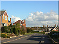
Crossdale Drive
Part of the privately developed sector of Keyworth to the north of the village.
Image: © Alan Murray-Rust
Taken: 1 Nov 2011
0.03 miles
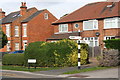
2
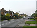
Nottingham Road, Keyworth
The pseudo-timber framing in the gables dates them to the interwar period, when there was significant ribbon development along the roads round the village.
Image: © Alan Murray-Rust
Taken: 11 Nov 2011
0.04 miles
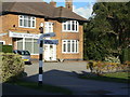
3
#2 Normanton Lane
Ordnance Survey documents indicate that in 1966 a benchmark levelled at 68.251m above Newlyn Datum was verified on the side rear corner of a house on this site. See www.bench-marks.org.uk/bm119876
Image: © Roger Templeman
Taken: 14 Sep 2018
0.06 miles
5
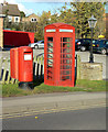
Nottingham Road postbox ref no NG12 152
Current style E II R pillar box outside the Fairway public house. The adjacent K6 telephone kiosk is no longer functioning, and is not listed, but appears to be well maintained.
Image: © Alan Murray-Rust
Taken: 1 Nov 2011
0.06 miles
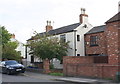
6
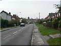
Normanton Lane, Keyworth
The area to the right started to be developed in the interwar period as Keyworth became a popular residential location for Nottingham commuters.
Image: © Alan Murray-Rust
Taken: 11 Nov 2011
0.07 miles
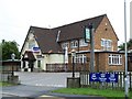
7
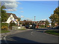
Nottingham Road at Debdale Lane
The pub is The Fairway, serving the northern part of Keyworth. It was advertising for new lessees although still open for business.
Image: © Alan Murray-Rust
Taken: 1 Nov 2011
0.07 miles
8
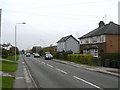
Normanton Lane, Keyworth
The two nearer buildings pre-date the interwar period, when there was significant ribbon development along the roads round the village.
Image: © Alan Murray-Rust
Taken: 11 Nov 2011
0.08 miles
9
Old style signpost at Debdale Lane / Nottingham Road junction
The signpost has Milestone Society National ID: NT_SK6131
Image: © Roger Templeman
Taken: 14 Sep 2018
0.09 miles
10
Fingerpost at the junction of Nottingham Road and Debdale Lane
The post is a traditional Notts C.C. concrete post with octagonal 'NCC' finial. The fingers are made of plastic rather than the traditional wood, but have applied moulded letters to at least match the style of traditional fingerposts.
Image: © Alan Murray-Rust
Taken: 1 Nov 2011
0.09 miles