IMAGES TAKEN NEAR TO
Walton Drive, NOTTINGHAM, NG12 5FP
Introduction
This page details the photographs taken nearby to Walton Drive, NG12 5FP by members of the Geograph project.
The Geograph project started in 2005 with the aim of publishing, organising and preserving representative images for every square kilometre of Great Britain, Ireland and the Isle of Man.

There are currently over 7.5m images from over14,400 individuals and you can help contribute to the project by visiting https://www.geograph.org.uk
Image Map
Images are licensed for reuse under creativecommons.org/licenses/by-sa/2.0
Notes
- Clicking on the map will re-center to the selected point.
- The higher the marker number, the further away the image location is from the centre of the postcode.
Image Listing (39 Images Found)
Images are licensed for reuse under creativecommons.org/licenses/by-sa/2.0
Image
Details
Distance
1
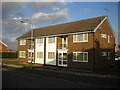
Walton Court, Keyworth
A small low rise block of flats on Walton Drive.
Image: © Richard Vince
Taken: 15 Oct 2016
0.07 miles
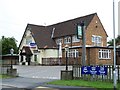
2
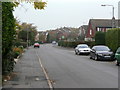
Wolds Drive
Looking north from near the shopping parade.
Image: © Alan Murray-Rust
Taken: 11 Nov 2011
0.08 miles
3
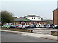
Budgen's Supermarket, Wolds Drive
The used to be a filling station on this site.
Image: © Alan Murray-Rust
Taken: 11 Nov 2011
0.12 miles
4
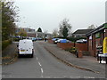
Church Drive
Looking up from Wolds Drive towards South Wolds Community Secondary school.
Image: © Alan Murray-Rust
Taken: 11 Nov 2011
0.12 miles
5
#2 Normanton Lane
Ordnance Survey documents indicate that in 1966 a benchmark levelled at 68.251m above Newlyn Datum was verified on the side rear corner of a house on this site. See www.bench-marks.org.uk/bm119876
Image: © Roger Templeman
Taken: 14 Sep 2018
0.13 miles
6
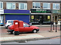
Wolds Drive Post Office postbox ref NG12 144
Modern style E II R pillar box with a large mail drop box attached.
Image: © Alan Murray-Rust
Taken: 11 Nov 2011
0.13 miles
7
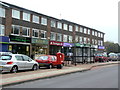
Wolds Drive Shops
Serving the large housing development to the east of the village. Still a reasonable variety of shops, not entirely takeaways.
Image: © Alan Murray-Rust
Taken: 11 Nov 2011
0.13 miles
9
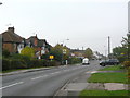
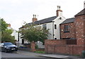
Nottingham Road, Keyworth
The pseudo-timber framing in the gables dates them to the interwar period, when there was significant ribbon development along the roads round the village.
Image: © Alan Murray-Rust
Taken: 11 Nov 2011
0.14 miles
10
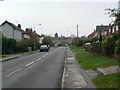
Normanton Lane, Keyworth
The area to the right started to be developed in the interwar period as Keyworth became a popular residential location for Nottingham commuters.
Image: © Alan Murray-Rust
Taken: 11 Nov 2011
0.15 miles