IMAGES TAKEN NEAR TO
Bradmore Lane, NOTTINGHAM, NG12 5EW
Introduction
This page details the photographs taken nearby to Bradmore Lane, NG12 5EW by members of the Geograph project.
The Geograph project started in 2005 with the aim of publishing, organising and preserving representative images for every square kilometre of Great Britain, Ireland and the Isle of Man.

There are currently over 7.5m images from over14,400 individuals and you can help contribute to the project by visiting https://www.geograph.org.uk
Image Map
Images are licensed for reuse under creativecommons.org/licenses/by-sa/2.0
Notes
- Clicking on the map will re-center to the selected point.
- The higher the marker number, the further away the image location is from the centre of the postcode.
Image Listing (139 Images Found)
Images are licensed for reuse under creativecommons.org/licenses/by-sa/2.0
Image
Details
Distance
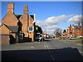
3
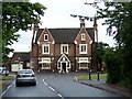
The Griffin at Plumtree
A large Victorian public house of 1843, doubtless erected at the expense of the local landowner. It originally had a farm attached which would probably have provided the landlord with his primary income.
Image: © Alan Murray-Rust
Taken: 11 Nov 2011
0.03 miles
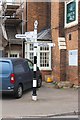
4
Fingerpost at Plumtree crossroads
Notts C.C. standard cast-iron design with ring finial.
Image: © Alan Murray-Rust
Taken: 11 Nov 2011
0.03 miles
5
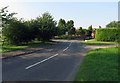
South end of Main Road, Plumtree
Seen from Station Road. The Griffin pub (left) had just been taken over when I visited, which meant food was not being served; this was unfortunate for me, as I had just worked up a decent appetite walking here from Ruddington.
Image: © Richard Vince
Taken: 27 Feb 2015
0.03 miles
6
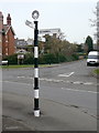
Signpost by The Griffin pub
The signpost has Milestone Society National ID: NT_SK6132
Image: © Roger Templeman
Taken: 14 Sep 2018
0.03 miles
7
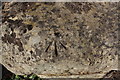
Benchmark on stone beside The Griffin pub
Ordnance Survey rivet benchmark levelled at 44.675m above Newlyn Datum
Image: © Roger Templeman
Taken: 15 Sep 2018
0.03 miles
8
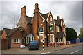
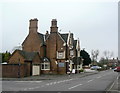
The Griffin public house
Image: © Roger Templeman
Taken: 14 Sep 2018
0.03 miles
9

The Griffin, Plumtree
There is a benchmark https://www.geograph.org.uk/photo/7080730 in the mounting stone at the foot of the wall.
Image: © Alan Murray-Rust
Taken: 23 Jan 2022
0.03 miles
10

Rivet Bench Mark, The Griffin, Plumtree
See https://www.geograph.org.uk/photo/7080732 for location. The stone has been worn down leaving the rivet a few millimetres above the surface. The arrow is picked out with moss.
Image: © Alan Murray-Rust
Taken: 23 Jan 2022
0.03 miles