IMAGES TAKEN NEAR TO
Maple Close, NOTTINGHAM, NG12 5DQ
Introduction
This page details the photographs taken nearby to Maple Close, NG12 5DQ by members of the Geograph project.
The Geograph project started in 2005 with the aim of publishing, organising and preserving representative images for every square kilometre of Great Britain, Ireland and the Isle of Man.

There are currently over 7.5m images from over14,400 individuals and you can help contribute to the project by visiting https://www.geograph.org.uk
Image Map
Images are licensed for reuse under creativecommons.org/licenses/by-sa/2.0
Notes
- Clicking on the map will re-center to the selected point.
- The higher the marker number, the further away the image location is from the centre of the postcode.
Image Listing (40 Images Found)
Images are licensed for reuse under creativecommons.org/licenses/by-sa/2.0
Image
Details
Distance
1
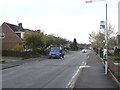
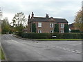
Fairway at Lilac Close
The main spine road of the 1960s/70s development of the eastern part of Keyworth.
Image: © Alan Murray-Rust
Taken: 1 Nov 2011
0.04 miles
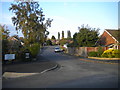
3
Willow Brook
This marks the effective eastern boundary of built-up Keyworth. Looking south from near Nicker Hill.
Image: © Alan Murray-Rust
Taken: 1 Nov 2011
0.07 miles
4
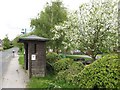
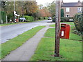
Bus shelter
Neat and tidy bus shelter of the 'old school', which is great to see, in Willow Brook.
Image: © Jonathan Wilkins
Taken: 12 May 2010
0.08 miles
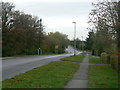
6
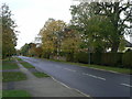
Nicker Hill, Keyworth
Looking northwest from the junction with Willow Brook. Housing along here developed in the form of ribbon development, consisting of large detached houses, during the inter-war period.
Image: © Alan Murray-Rust
Taken: 1 Nov 2011
0.12 miles
7
Haywards Corner postbox ref no NG12 334
EIIR lampbox still attached to a telegraph pole.
Image: © Alan Murray-Rust
Taken: 1 Nov 2011
0.12 miles
8
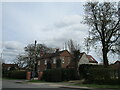
Hill Crest
Late 19th century house, built as an isolated dwelling substantially earlier than the rest of the neighbourhood.
Image: © Alan Murray-Rust
Taken: 1 Nov 2011
0.12 miles
9
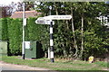
Signpost at Stanton Lane / Willow Brook junction
The signpost has Milestone Society National ID: NT_SK6230B
Image: © Roger Templeman
Taken: 14 Sep 2018
0.13 miles
10
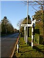
Fingerpost at Haywards Corner
Looking along Nicker Hill.
Notts CC standard concrete octagonal post with octagonal finial.
Image: © Alan Murray-Rust
Taken: 17 Jan 2022
0.13 miles