IMAGES TAKEN NEAR TO
Browns Lane, NOTTINGHAM, NG12 5BL
Introduction
This page details the photographs taken nearby to Browns Lane, NG12 5BL by members of the Geograph project.
The Geograph project started in 2005 with the aim of publishing, organising and preserving representative images for every square kilometre of Great Britain, Ireland and the Isle of Man.

There are currently over 7.5m images from over14,400 individuals and you can help contribute to the project by visiting https://www.geograph.org.uk
Image Map
Images are licensed for reuse under creativecommons.org/licenses/by-sa/2.0
Notes
- Clicking on the map will re-center to the selected point.
- The higher the marker number, the further away the image location is from the centre of the postcode.
Image Listing (24 Images Found)
Images are licensed for reuse under creativecommons.org/licenses/by-sa/2.0
Image
Details
Distance
1
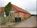
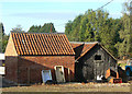
Farm buildings conversion
Farm buildings at Larel Farm have been converted to a couple of mews-style apartments. The road leads to the church.
Image: © Jonathan Wilkins
Taken: 12 May 2010
0.03 miles
2
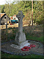
War memorial
Commemorating the dead of the 1914-18 war. The old hamlet has no real centre so the churchyard would have been the obvious place to site the memorial. The size of the village is indicated by the fact that just three names are listed, two of which share the same surname.
Image: © Alan Murray-Rust
Taken: 20 Oct 2011
0.05 miles
3
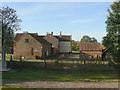
Glebe Farm
Adjacent to the parish church. The name only appears on recent editions of the OS maps, the house having previously been marked as 'Rectory'. The farm would doubtless have covered the glebe lands which would have supported the rector's living, even if he himself did not actively farm the land.
Image: © Alan Murray-Rust
Taken: 20 Oct 2011
0.05 miles
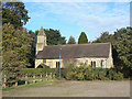
4
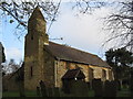
Church of All Saints, Stanton-on-the-Wolds
http://southwellchurches.nottingham.ac.uk/stanton-on-the-wolds/hintro.php
Image: © Tim Heaton
Taken: 8 Dec 2005
0.06 miles
5
Sheds at Glebe Farm
As is so often the case with farms, there is an interesting selection of discarded items.
Image: © Alan Murray-Rust
Taken: 20 Oct 2011
0.06 miles
6
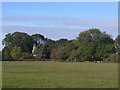
View towards Stanton Church
The distinctive bell turret of this unassuming church peeps through the surrounding trees.
Image: © Alan Murray-Rust
Taken: 20 Oct 2011
0.06 miles
7
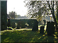
Stanton Churchyard
October morning sunlight glistens on the dew.
Image: © Alan Murray-Rust
Taken: 20 Oct 2011
0.06 miles
8
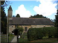
All Saints' Church, Stanton on the Wolds
Image: © Richard Vince
Taken: 25 Aug 2018
0.07 miles
9
All Saints, Stanton on the Wolds
The south wall retains some original 11th century masonry, but the church was heavily rebuilt during the 19th century. Listed Grade II.
Image: © Alan Murray-Rust
Taken: 20 Oct 2011
0.07 miles
10
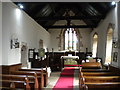
Interior of All Saints' Church, Stanton on the Wolds
Looking towards the High Altar and the east window.
Image: © Richard Vince
Taken: 25 Aug 2018
0.07 miles