IMAGES TAKEN NEAR TO
Lings Lane, NOTTINGHAM, NG12 5AY
Introduction
This page details the photographs taken nearby to Lings Lane, NG12 5AY by members of the Geograph project.
The Geograph project started in 2005 with the aim of publishing, organising and preserving representative images for every square kilometre of Great Britain, Ireland and the Isle of Man.

There are currently over 7.5m images from over14,400 individuals and you can help contribute to the project by visiting https://www.geograph.org.uk
Image Map
Images are licensed for reuse under creativecommons.org/licenses/by-sa/2.0
Notes
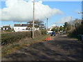
- Clicking on the map will re-center to the selected point.
- The higher the marker number, the further away the image location is from the centre of the postcode.
Image Listing (77 Images Found)
Images are licensed for reuse under creativecommons.org/licenses/by-sa/2.0
Image
Details
Distance
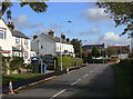
1
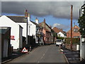
Main Street
The traditional part of the village which expanded enormously in the 20th century, particularly after World War II.
Image: © Alan Murray-Rust
Taken: 1 Nov 2011
0.04 miles
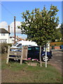
2
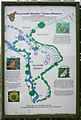
Information board, Keyworth Meadow Nature Reserve
Although the meadow is quite a way down the lane, the board is at the junction of Lings Lane with Main Street. See http://www.keyworth-meadow.tk
Image: © Kate Jewell
Taken: 17 Oct 2006
0.05 miles
3
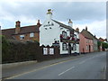
The Salutation pub, Keyworth
On Main Street.
Image: © JThomas
Taken: 21 Jun 2014
0.05 miles
4
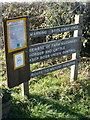
Bridleway sign
It's unfortunate that there should be a need to reinforce the regulations so heavily.
Image: © Alan Murray-Rust
Taken: 1 Nov 2011
0.06 miles
5
Commemorative oak tree
The small plaque of the back of the sign indicates that the tree was planted to commemorate the 'Best kept village' award in 1990.
Image: © Alan Murray-Rust
Taken: 1 Nov 2011
0.06 miles
6
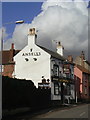
The Salutation
One of two pubs in the older part of the village, the other being The Plough http://www.geograph.org.uk/photo/1383925.
Image: © Alan Murray-Rust
Taken: 1 Nov 2011
0.06 miles
7
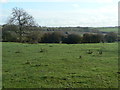
View from Lings Lane
Looking across to Keyworth Wolds.
Image: © Alan Murray-Rust
Taken: 1 Nov 2011
0.06 miles
8
Wysall Lane
The southern edge of the village, with houses from around the turn of the 20th century.
Image: © Alan Murray-Rust
Taken: 1 Nov 2011
0.06 miles
9
The top of Lings Lane
Designated as a bridleway, it nevertheless provides vehicular access to a number of dwellings and several paddocks.
Image: © Alan Murray-Rust
Taken: 1 Nov 2011
0.07 miles
10
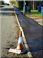
Wet tar
Newly resurfaced pavement - but in fact the wetness was more from the water put down to prevent it sticking! On Wysall Lane.
Image: © Alan Murray-Rust
Taken: 1 Nov 2011
0.08 miles