IMAGES TAKEN NEAR TO
Alison Close, NG12 4LA
Introduction
This page details the photographs taken nearby to Alison Close, NG12 4LA by members of the Geograph project.
The Geograph project started in 2005 with the aim of publishing, organising and preserving representative images for every square kilometre of Great Britain, Ireland and the Isle of Man.

There are currently over 7.5m images from over14,400 individuals and you can help contribute to the project by visiting https://www.geograph.org.uk
Image Map
Images are licensed for reuse under creativecommons.org/licenses/by-sa/2.0
Notes
- Clicking on the map will re-center to the selected point.
- The higher the marker number, the further away the image location is from the centre of the postcode.
Image Listing (22 Images Found)
Images are licensed for reuse under creativecommons.org/licenses/by-sa/2.0
Image
Details
Distance
1
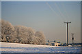
Sharphill Wood and Roberts Farm
Everything covered in a thick hoar frost, including the power lines.
Image: © David Lally
Taken: 7 Dec 2010
0.12 miles
2
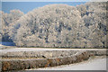
Sharphill Wood
From the strange stub of road seen in Image
This was taken about 1 p.m. the temperature was approximately -3.5C.
Image: © David Lally
Taken: 7 Dec 2010
0.16 miles
3
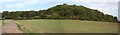
Sharphill Wood
Seen from Spinney Hill.
Image: © Alan Murray-Rust
Taken: 23 Sep 2008
0.18 miles

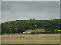
6
Sharphill Wood
Viewed from an access road on the eastbound carriageway of the A606. In 2006, Rushcliffe Council wanted to build 1200 new houses on this site but, after a vigorous campaign by protesters, on 15th June they decided not to go ahead.
Image: © Les Carruthers
Taken: 21 Sep 2006
0.19 miles
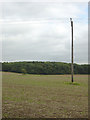
8
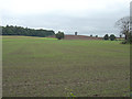
Fields alongside Melton Road
Looking towards Sharp Hill
Image: © Alan Murray-Rust
Taken: 23 Sep 2008
0.20 miles
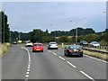
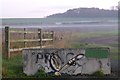
9
Nottingham - NG2 (A52)
A view from the closed end of Landmere Lane (a cul-de-sac) looking towards Melton Road (the A606). This lane was chopped into two (when ?) by the construction of the A52, a dual carriageway on the right of the photographer. A small business park now exists at this end of the lane, as does the popular Wheatcroft Garden Centre that is located behind the trees beyond the flag pole. The lane itself peters out on the left, leading into a large car park and to nearby Roberts Farm.
Image: © David Hallam-Jones
Taken: 9 Jun 2012
0.21 miles
10
A52 and Sharphill Wood
From the bridleway to Ruddington.
Image: © Alan Murray-Rust
Taken: 23 Sep 2008
0.22 miles