IMAGES TAKEN NEAR TO
Wisteria Drive, NOTTINGHAM, NG12 4HZ
Introduction
This page details the photographs taken nearby to Wisteria Drive, NG12 4HZ by members of the Geograph project.
The Geograph project started in 2005 with the aim of publishing, organising and preserving representative images for every square kilometre of Great Britain, Ireland and the Isle of Man.

There are currently over 7.5m images from over14,400 individuals and you can help contribute to the project by visiting https://www.geograph.org.uk
Image Map
Images are licensed for reuse under creativecommons.org/licenses/by-sa/2.0
Notes
- Clicking on the map will re-center to the selected point.
- The higher the marker number, the further away the image location is from the centre of the postcode.
Image Listing (25 Images Found)
Images are licensed for reuse under creativecommons.org/licenses/by-sa/2.0
Image
Details
Distance
1
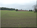
Fields alongside Melton Road
Looking towards Sharp Hill
Image: © Alan Murray-Rust
Taken: 23 Sep 2008
0.13 miles
2

Sharphill Wood and Roberts Farm
Everything covered in a thick hoar frost, including the power lines.
Image: © David Lally
Taken: 7 Dec 2010
0.13 miles
3
Private Road to John Wells
Also a public footpath to where the yellow marker can be seen in the hedge.
Image: © Alan Murray-Rust
Taken: 23 Sep 2008
0.16 miles
4
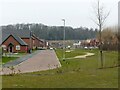
Sunflower Drive, Edwalton Fields
This is on the site of the former Wheatcroft nurseries, and roads are named after flowers in token of that. Sharphill Wood in the distance.
Image: © Alan Murray-Rust
Taken: 23 Jan 2022
0.17 miles
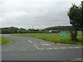
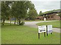
5
Access road to industrial estate south of Edwalton
Image: © Richard Vince
Taken: 29 Nov 2014
0.17 miles
6

Balancing pond, Edwalton Fields
This appears to have been deliberately developed more as wetland than pond.
Image: © Alan Murray-Rust
Taken: 23 Jan 2022
0.18 miles
7

Edwalton: towards Sharphill Wood
A view across a field of oilseed rape next to the A606, taken on the morning of the May Day Bank Holiday.
Image: © John Sutton
Taken: 2 May 2016
0.18 miles
8
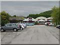
Wheatcrofts Garden Centre
Once home of the famous roses, it has passed out of the hands of the Wheatcroft family, although the name is retained. Viewed from the footpath past the car park (which is now further east than is shown on either the 1:50000 or 1:25000 maps).
Image: © Alan Murray-Rust
Taken: 23 Sep 2008
0.18 miles
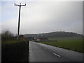
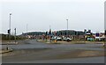
9
Landmere Lane
The nearer roadway is part of the old Landmere Lane, now superseded by the A52 Ring Road. The old rural character has been completely lost - this section now sports a small business park.
Image: © Alan Murray-Rust
Taken: 23 Sep 2008
0.19 miles
10
Rose Way, Edwalton
The entrance to the large Edwalton Fields housing development. This is partly on the site of the former Wheatcroft nurseries, and roads are named after flowers in token of that.
Image: © Alan Murray-Rust
Taken: 23 Jan 2022
0.20 miles