1
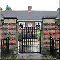
Edwalton: the gate of the Hind Almshouses
These almshouses were built in 1927 by Oliver Hind of Edwalton Hall, in memory of his parents and of his brother and a nephew, both of whom were killed on The Somme.
Image: © John Sutton
Taken: 25 Sep 2013
0.09 miles
2
Edwalton: the Hind Almshouses
These almshouses were built in 1927 by Oliver Hind of Edwalton Hall. Plaques either side of the gate record that they were built in memory of his parents and of his brother, Lt Col Lawrence Hind MC, killed leading his battalion on the first day of The Somme, and a nephew, Lt Jesse Hind, wounded at Gallipoli and killed at Thiepval on The Somme.
Image: © John Sutton
Taken: 25 Sep 2013
0.09 miles
3
Edwalton Village sign
At the junction of Village Street and Wellin Lane. New since the last time I was around this way.
Image: © David Lally
Taken: 10 Jan 2013
0.10 miles
4
Footpath across Edwalton golf course
Image: © Richard Vince
Taken: 29 Nov 2014
0.14 miles
5
Footpath at Edwalton
Recreating this 'First' for the square https://www.geograph.org.uk/photo/229031
Image: © Alan Murray-Rust
Taken: 23 Jan 2022
0.14 miles
6
Footpath at Edwalton
The land on both sides of the footpath dips down as it crosses a former railway line. The gate at the end leads to Edwalton Golf Course.
Image: © Catherine Davis
Taken: 30 Aug 2006
0.15 miles
7
Site of railway bridge
On a footpath near Edwalton which makes use of the site of a bridge over the former Nottingham to Melton railway.
Image: © Alan Murray-Rust
Taken: 23 Jan 2022
0.15 miles
8
Old railway bed
This was the Midland Railway alternative main line to Nottingham via Oakham and Melton Mowbray.
Image: © Alan Murray-Rust
Taken: 23 Sep 2008
0.16 miles
9
Edwalton: where the footpath once crossed the railway
In the centre of the picture are the remains of the red-brick parapets of an occupation bridge - now filled in - over the Midland main line from Nottingham to Melton, Oakham, Corby and Kettering, which closed in the 1960s.
Image: © John Sutton
Taken: 2 May 2016
0.16 miles
10
Overgrown railway formation, Edwalton
The cutting that once hosted the Midland Railway's line between Nottingham and Melton Mowbray as it passed Edwalton is now almost invisible beneath foliage. Only a little way south of here, the railway is still present, in the form of the Old Dalby test track.
Image: © Richard Vince
Taken: 29 Nov 2014
0.16 miles


