IMAGES TAKEN NEAR TO
Plane Road, NOTTINGHAM, NG12 4GT
Introduction
This page details the photographs taken nearby to Plane Road, NG12 4GT by members of the Geograph project.
The Geograph project started in 2005 with the aim of publishing, organising and preserving representative images for every square kilometre of Great Britain, Ireland and the Isle of Man.

There are currently over 7.5m images from over14,400 individuals and you can help contribute to the project by visiting https://www.geograph.org.uk
Image Map
Images are licensed for reuse under creativecommons.org/licenses/by-sa/2.0
Notes
- Clicking on the map will re-center to the selected point.
- The higher the marker number, the further away the image location is from the centre of the postcode.
Image Listing (36 Images Found)
Images are licensed for reuse under creativecommons.org/licenses/by-sa/2.0
Image
Details
Distance
2
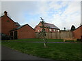
Token tree
A blue cedar planted on a small area of grass in a modern housing estate. If allowed to grow to full size it will be an impressive feature.
Image: © Jonathan Thacker
Taken: 19 Nov 2022
0.11 miles
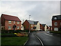
4
Acacia Way, Edwalton
The entrance to Edwalton Park housing development. The roads are all named after trees.
Image: © Alan Murray-Rust
Taken: 23 Jan 2022
0.14 miles
5

Edwalton Golf Course, 3rd hole tee
The standard tee platforms are roped off to prevent damage during the winter period, with a temporary plastic tee mat installed in place.
Image: © Alan Murray-Rust
Taken: 23 Jan 2022
0.14 miles
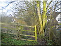
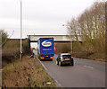
6
Bridge under the railway near Edwalton
Since the creation of the new Edwalton Park housing, this bridge has no function whatsoever.
Image: © Alan Murray-Rust
Taken: 23 Jan 2022
0.14 miles
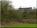
7
Railway Bridge, Lings Bar Road
By the time the bridge was built in 1981, the railway had already been closed to normal service and converted to a test track. Despite the fact that the terminus of the line is only a couple of hundred metres further on, a bridge was constructed rather than cut the line short. Furthermore, the bridge was built with sufficient span to accommodate a second carriageway, although after more than 30 years there is still no sign of this.
Image: © Alan Murray-Rust
Taken: 24 Jan 2014
0.16 miles
8
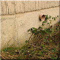
Bench mark, Lings Bar Road railway bridge
This is a relatively late mark, as the road and bridge were not constructed until the 1981. See http://www.geograph.org.uk/photo/3825874 for location; the mark is on the east side of the northern abutment.
Image: © Alan Murray-Rust
Taken: 24 Jan 2014
0.16 miles