IMAGES TAKEN NEAR TO
Tollerton Lane, NOTTINGHAM, NG12 4GA
Introduction
This page details the photographs taken nearby to Tollerton Lane, NG12 4GA by members of the Geograph project.
The Geograph project started in 2005 with the aim of publishing, organising and preserving representative images for every square kilometre of Great Britain, Ireland and the Isle of Man.

There are currently over 7.5m images from over14,400 individuals and you can help contribute to the project by visiting https://www.geograph.org.uk
Image Map
Images are licensed for reuse under creativecommons.org/licenses/by-sa/2.0
Notes
- Clicking on the map will re-center to the selected point.
- The higher the marker number, the further away the image location is from the centre of the postcode.
Image Listing (50 Images Found)
Images are licensed for reuse under creativecommons.org/licenses/by-sa/2.0
Image
Details
Distance
1
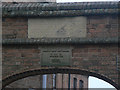
Inscribed stones at North End Cottages
The upper stone clearly predates the 1921 inscription, but is now totally illegible. Older maps show a school on the site so it probably is related to that. The 'AMB' probably refers to a member of the Burnside family who were local landowners.
Image: © Alan Murray-Rust
Taken: 11 Nov 2011
0.01 miles
2
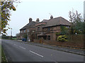
North End Cottages
The arch is dated 1921, but older maps show buildings on the site so they were doubtless reconstructed at that date. The architectural style is unusual for estate cottages.
Image: © Alan Murray-Rust
Taken: 11 Nov 2011
0.01 miles
3
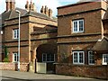
North End Cottages, Tollerton
There is a bench mark https://www.geograph.org.uk/photo/7084830 on the stone gatepost on the left of the entrance.
Image: © Alan Murray-Rust
Taken: 30 Jan 2022
0.02 miles
4
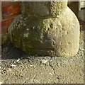
Bench Mark, North End Cottages, Tollerton
Nearly covered over with successive layers of pavement tarmac. See https://www.geograph.org.uk/photo/7084836 for location.
Image: © Alan Murray-Rust
Taken: 30 Jan 2022
0.02 miles
6
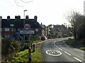
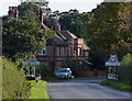
Tollerton Village
Recreating this ‘First’ for the square https://www.geograph.org.uk/photo/51959
Image: © Alan Murray-Rust
Taken: 30 Jan 2022
0.02 miles
7
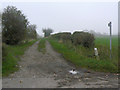
Farm track north of Tollerton
Also hosting a public footpath to Cotgrave.
Image: © Richard Vince
Taken: 13 Aug 2016
0.03 miles
8
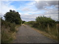
Farm track near Tollerton
Part of a public footpath link to Cotgrave.
Image: © Alan Murray-Rust
Taken: 11 Nov 2011
0.04 miles
9
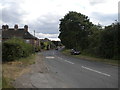
Tollerton in Nottinghamshire
Tollerton Lane on the northern edge of the village.
Image: © Mat Fascione
Taken: 6 Oct 2013
0.04 miles
10
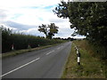
Tollerton Lane north of Tollerton (1)
Looking towards Nottingham Airport and Gamston.
Image: © Richard Vince
Taken: 13 Aug 2016
0.05 miles