IMAGES TAKEN NEAR TO
Melton Road, NOTTINGHAM, NG12 4EL
Introduction
This page details the photographs taken nearby to Melton Road, NG12 4EL by members of the Geograph project.
The Geograph project started in 2005 with the aim of publishing, organising and preserving representative images for every square kilometre of Great Britain, Ireland and the Isle of Man.

There are currently over 7.5m images from over14,400 individuals and you can help contribute to the project by visiting https://www.geograph.org.uk
Image Map
Images are licensed for reuse under creativecommons.org/licenses/by-sa/2.0
Notes
- Clicking on the map will re-center to the selected point.
- The higher the marker number, the further away the image location is from the centre of the postcode.
Image Listing (32 Images Found)
Images are licensed for reuse under creativecommons.org/licenses/by-sa/2.0
Image
Details
Distance
1
Bench mark, Lenton Avenue, Tollerton
On the west side at the junction with Melton Road. This does not appear on OS maps until the 1960s.
Image: © Alan Murray-Rust
Taken: 24 Jan 2014
0.02 miles
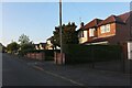
3
Lenton Avenue
Tudorbethan houses give the clue to the fact that most of the current village dates from the 1930s and later.
Image: © Alan Murray-Rust
Taken: 8 Dec 2009
0.06 miles
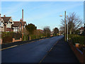
4
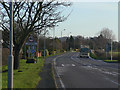
A606 at Tollerton
The main road from Nottingham to Melton Mowbray and the A46 skirts the edge of the village.
Image: © Alan Murray-Rust
Taken: 8 Dec 2009
0.07 miles
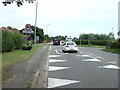
5
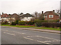
Houses along Melton Road
These formed typical inter-war ribbon development before Tollerton expanded to create the present residential area.
There is a bench mark http://www.geograph.org.uk/photo/3825895 just to the left of the green gatepost.
Image: © Alan Murray-Rust
Taken: 24 Jan 2014
0.09 miles
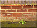
6
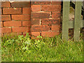
Bench mark, #41 Melton Road, Tollerton
A slightly decrepit mark on the end of the garden wall alongside Melton Road http://www.geograph.org.uk/photo/3825896
Image: © Alan Murray-Rust
Taken: 24 Jan 2014
0.11 miles
7
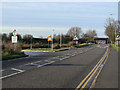
Only high vehicles allowed
The eastern turnback point with the bridge in the distance.
Image: © Alan Murray-Rust
Taken: 8 Dec 2009
0.11 miles
8
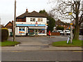
Tollerton Post Office and stores
The facade has had a face lift since David Lally's 2010 picture http://www.geograph.org.uk/photo/2152046 . The telephone kiosk has also been removed.
Image: © Alan Murray-Rust
Taken: 24 Jan 2014
0.12 miles
9
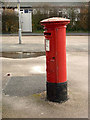
Tollerton Post Office postbox ref NG12 62
This is an EVIIR pillar box, but there was no development in the area until well after World War I, so it's a puzzle as to where it may have come from. See also http://www.geograph.org.uk/photo/3828002
Image: © Alan Murray-Rust
Taken: 24 Jan 2014
0.12 miles