IMAGES TAKEN NEAR TO
Hose Lane, NOTTINGHAM, NG12 3UU
Introduction
This page details the photographs taken nearby to Hose Lane, NG12 3UU by members of the Geograph project.
The Geograph project started in 2005 with the aim of publishing, organising and preserving representative images for every square kilometre of Great Britain, Ireland and the Isle of Man.

There are currently over 7.5m images from over14,400 individuals and you can help contribute to the project by visiting https://www.geograph.org.uk
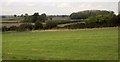
Image Map
Images are licensed for reuse under creativecommons.org/licenses/by-sa/2.0
Notes
- Clicking on the map will re-center to the selected point.
- The higher the marker number, the further away the image location is from the centre of the postcode.
Image Listing (17 Images Found)
Images are licensed for reuse under creativecommons.org/licenses/by-sa/2.0
Image
Details
Distance
1
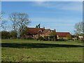
The House on the Hill
The new name of the former Colstonhills Farm following conversion to purely residential use.
Image: © Alan Murray-Rust
Taken: 25 Oct 2020
0.00 miles
2
The House on the Hill
With a pill box on the right (see Image).
Image: © Tim Heaton
Taken: 17 Mar 2022
0.01 miles
3
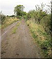
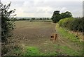
Farm track, The House on the Hill
From Colston Bassett footpath 9 as it joins the track after crossing the field shown in Image
Image: © Derek Harper
Taken: 11 Oct 2014
0.05 miles
4
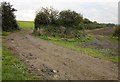
Path at The House on the Hill
Colston Bassett footpath 9 goes through the left-hand of these gateways. The hunt is not welcome through the right-hand one, according to the notice.
Image: © Derek Harper
Taken: 11 Oct 2014
0.09 miles
5
Countryside near The House on the Hill
Colston Bassett footpath 9 crosses to the corner of this field to go through the gateway left of centre, seen in reverse in Image The small wood beyond can be seen in Image]; the larger wood to the right is South Hill Plantation - see Image
Image: © Derek Harper
Taken: 11 Oct 2014
0.10 miles
6
Farmland, The House on the Hill
A view from Colston Bassett footpath 9, which doesn't go this way - and nor does the hunt.
Image: © Derek Harper
Taken: 11 Oct 2014
0.11 miles
7

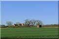
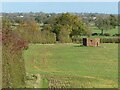
Not as featureless as it seems at first sight
The light bumps on the horizon indicate the former presence of medieval ridge and furrow agriculture, and I am sure that the clouds would give a clue to a knowledgeable meteorologist as to what could be happening to the weather.
Image: © Alan Murray-Rust
Taken: 25 Oct 2020
0.14 miles
8
Pill box on the edge of Pen Hill
Type 22 hexagonal pillbox, with brick shuttering, S0000517 in the Defence of Britain database https://archaeologydataservice.ac.uk/archives/view/dob/ai_full_r.cfm?refno=517 . See http://www.geograph.org.uk/photo/6655244 for a close view.
Image: © Alan Murray-Rust
Taken: 25 Oct 2020
0.15 miles
9
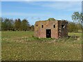
Pill box on the edge of Pen Hill
Type 22 hexagonal pillbox, with brick shuttering, S0000517 in the Defence of Britain database https://archaeologydataservice.ac.uk/archives/view/dob/ai_full_r.cfm?refno=517 . See also http://www.geograph.org.uk/photo/6655239
Image: © Alan Murray-Rust
Taken: 25 Oct 2020
0.15 miles
10

Path by Roses Farm
Windfalls by the farm as Colston Bassett FP9 heads diagonally across the field towards The House on the Hill.
Image: © Derek Harper
Taken: 11 Oct 2014
0.16 miles