IMAGES TAKEN NEAR TO
Cherry Orchard, NOTTINGHAM, NG12 3TR
Introduction
This page details the photographs taken nearby to Cherry Orchard, NG12 3TR by members of the Geograph project.
The Geograph project started in 2005 with the aim of publishing, organising and preserving representative images for every square kilometre of Great Britain, Ireland and the Isle of Man.

There are currently over 7.5m images from over14,400 individuals and you can help contribute to the project by visiting https://www.geograph.org.uk
Image Map
Images are licensed for reuse under creativecommons.org/licenses/by-sa/2.0
Notes
- Clicking on the map will re-center to the selected point.
- The higher the marker number, the further away the image location is from the centre of the postcode.
Image Listing (76 Images Found)
Images are licensed for reuse under creativecommons.org/licenses/by-sa/2.0
Image
Details
Distance
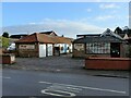
1
Butchers, Bakers and not candlestick makers
See http://www.geograph.org.uk/photo/7067728 for location.
Image: © Alan Murray-Rust
Taken: 9 Jan 2022
0.06 miles
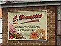
2
Brumpton's, Plumtree Road, Cotgrave
Local family firm of butchers and bakers, occupying in part old farm buildings.
Image: © Alan Murray-Rust
Taken: 9 Jan 2022
0.06 miles
4
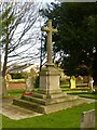
Cotgrave War Memorial
Designed by architect Lt Col Arthur William Brewill (1861-1923) and erected in 1920. There are commemorative panels http://www.geograph.org.uk/photo/7067773 on the far face of the memorial, but the sun was at an inconvenient angle to get the whole monument with the panels. Listed Grade II.
Image: © Alan Murray-Rust
Taken: 9 Jan 2022
0.06 miles
5
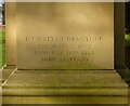
Cotgrave War Memorial ? detail
This inscription was clearly added at a late stage after the main panel had been prepared. The memorial was unveiled in June 1920. See http://www.geograph.org.uk/photo/7067779 for location.
Image: © Alan Murray-Rust
Taken: 9 Jan 2022
0.06 miles
6

Cotgrave War Memorial ? detail
Bronze panels on the east face with commemorative details. See http://www.geograph.org.uk/photo/7067779 for location.
Image: © Alan Murray-Rust
Taken: 9 Jan 2022
0.06 miles
8
Manvers monogram, Cotgrave C of E Primary School
See http://www.geograph.org.uk/photo/7067972 for location.
Image: © Alan Murray-Rust
Taken: 9 Jan 2022
0.06 miles
9
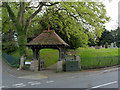
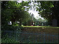
Lych gate, Cotgrave Cemetery
Built in 1899 by local landowner the third Earl Manvers, using oak from Sherwood Forest. It features on the new village sign on Owthorpe Road http://www.geograph.org.uk/photo/3958210
Image: © Alan Murray-Rust
Taken: 27 Apr 2014
0.06 miles
10
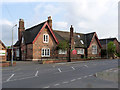
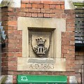
Cotgrave C of E Primary School
The school still occupies the original 1863 building. The stone panel in the central chimney carries a coroneted M, representing the local landowners, the Earls Manvers.
Image: © Alan Murray-Rust
Taken: 27 Apr 2014
0.06 miles