IMAGES TAKEN NEAR TO
Deans Court, NOTTINGHAM, NG12 3LS
Introduction
This page details the photographs taken nearby to Deans Court, NG12 3LS by members of the Geograph project.
The Geograph project started in 2005 with the aim of publishing, organising and preserving representative images for every square kilometre of Great Britain, Ireland and the Isle of Man.

There are currently over 7.5m images from over14,400 individuals and you can help contribute to the project by visiting https://www.geograph.org.uk
Image Map
Images are licensed for reuse under creativecommons.org/licenses/by-sa/2.0
Notes
- Clicking on the map will re-center to the selected point.
- The higher the marker number, the further away the image location is from the centre of the postcode.
Image Listing (31 Images Found)
Images are licensed for reuse under creativecommons.org/licenses/by-sa/2.0
Image
Details
Distance
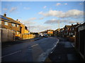
1
South end of Avondale, Cotgrave
Seen from Lingford.
Image: © Richard Vince
Taken: 24 Feb 2015
0.06 miles
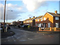
2
Ring Leas
The main road of the major expansion of the village following the development of the nearby colliery, now gone without trace.
Image: © Alan Murray-Rust
Taken: 6 Dec 2009
0.09 miles
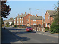
3
Lingford, Cotgrave
A residential road between Woodview and Ring Leas.
Image: © Richard Vince
Taken: 24 Feb 2015
0.09 miles
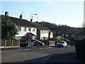
4
Flats on Woodview
The bulk of the accommodation for colliery workers was in semi-detached houses, but a small number of flats/maisonettes was also incorporated in the development.
Image: © Alan Murray-Rust
Taken: 3 Oct 2011
0.11 miles
5
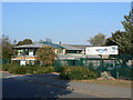
Cotgrave Leisure Centre
This also houses the local Town Council and Business Development Centre.
Image: © Alan Murray-Rust
Taken: 3 Oct 2011
0.13 miles
6
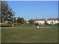
Cotgrave Green
Not the original village green, but an area of open space adjacent to the new shopping centre created as part of the development of Cotgrave as a colliery village in the 1950s/60s.
Image: © Alan Murray-Rust
Taken: 3 Oct 2011
0.13 miles
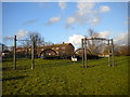
7
Park on Candleby Lane, Cotgrave (2)
The east end of the park, looking towards the houses on Avondale.
Image: © Richard Vince
Taken: 24 Feb 2015
0.14 miles
8

Cotgrave Colliery tableau
Commemorating Cotgrave's short-lived mining heritage. The local colliery opened in 1964 and closed in 1993.
Image: © Graham Hogg
Taken: 28 Feb 2017
0.16 miles
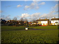
9
Park on Candleby Lane, Cotgrave (1)
There was a colliery in Cotgrave for much of the second half of the 20th century, which caused the village to expand rapidly and considerably. This park near the centre of the village commemorates that part of its history.
Image: © Richard Vince
Taken: 24 Feb 2015
0.17 miles
10

The Cotgrave Hub
A brand new (2019) development in the centre of Cotgrave including library, police station, council offices and health centre. An excellent concentration of local services at the heart of the community.
Image: © Alan Murray-Rust
Taken: 9 Jan 2022
0.17 miles