IMAGES TAKEN NEAR TO
Risegate, NOTTINGHAM, NG12 3JF
Introduction
This page details the photographs taken nearby to Risegate, NG12 3JF by members of the Geograph project.
The Geograph project started in 2005 with the aim of publishing, organising and preserving representative images for every square kilometre of Great Britain, Ireland and the Isle of Man.

There are currently over 7.5m images from over14,400 individuals and you can help contribute to the project by visiting https://www.geograph.org.uk
Image Map
Images are licensed for reuse under creativecommons.org/licenses/by-sa/2.0
Notes
- Clicking on the map will re-center to the selected point.
- The higher the marker number, the further away the image location is from the centre of the postcode.
Image Listing (84 Images Found)
Images are licensed for reuse under creativecommons.org/licenses/by-sa/2.0
Image
Details
Distance
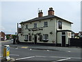
1
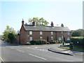
Cottages on Risegate
Close to the modern shopping centre, a reminder that Cotgrave was once a small rural village.
Image: © Alan Murray-Rust
Taken: 3 Oct 2011
0.05 miles
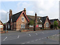
2
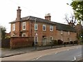
2 Main Road, Cotgrave
Early 19th century 3-bay house attached to an earlier – late 18th century – former farmhouse. Now a single dwelling. Listed Grade II.
Image: © Alan Murray-Rust
Taken: 9 Jan 2022
0.08 miles
3
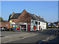
Not your average Sainsbury's
The Cotgrave branch makes use of some of the older buildings in the original part of the village. The store is in fact extended considerably at the rear of the houses.
Image: © Alan Murray-Rust
Taken: 3 Oct 2011
0.09 miles
5
Manvers monogram, Cotgrave C of E Primary School
See http://www.geograph.org.uk/photo/7067972 for location.
Image: © Alan Murray-Rust
Taken: 9 Jan 2022
0.10 miles

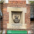
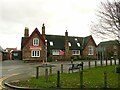
9
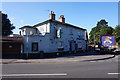
Cotgrave C of E Primary School
The school still occupies the original 1863 building. The stone panel in the central chimney carries a coroneted M, representing the local landowners, the Earls Manvers.
Image: © Alan Murray-Rust
Taken: 27 Apr 2014
0.10 miles
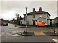
10
Cotgrave C of E Primary School
The school still occupies the original 1863 building. The stone panel http://www.geograph.org.uk/photo/7067974 in the central chimney carries a coroneted M, representing the local landowners, the Earls Manvers.
A traffic island to assist pedestrians has been installed since my 2014 visit https://www.geograph.org.uk/photo/3958218
Image: © Alan Murray-Rust
Taken: 9 Jan 2022
0.10 miles