IMAGES TAKEN NEAR TO
Colliers Way, NOTTINGHAM, NG12 3HA
Introduction
This page details the photographs taken nearby to Colliers Way, NG12 3HA by members of the Geograph project.
The Geograph project started in 2005 with the aim of publishing, organising and preserving representative images for every square kilometre of Great Britain, Ireland and the Isle of Man.

There are currently over 7.5m images from over14,400 individuals and you can help contribute to the project by visiting https://www.geograph.org.uk
Image Map
Images are licensed for reuse under creativecommons.org/licenses/by-sa/2.0
Notes
- Clicking on the map will re-center to the selected point.
- The higher the marker number, the further away the image location is from the centre of the postcode.
Image Listing (21 Images Found)
Images are licensed for reuse under creativecommons.org/licenses/by-sa/2.0
Image
Details
Distance
2
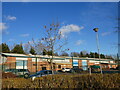
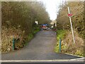
Harvest Drive, Hollygate, Cotgrave
Unusually, a new housing development for which public transport provision has been made at an early stage of development. The road layout has enabled the diversion of an existing service between Nottingham and the Cropwells with little extra mileage.
Image: © Alan Murray-Rust
Taken: 9 Jan 2022
0.05 miles
4
Cotgrave colliery site
Recreating this 'First' for the square http://www.geograph.org.uk/photo/195894 , now completely changed by the presence of the new Hollygate housing development. The location has been established by reference to historic satellite views on Google Earth. Fortunately it proved to be on the line of the new road rather than under someone's house!
Image: © Alan Murray-Rust
Taken: 9 Jan 2022
0.08 miles
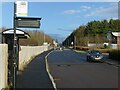
5
Entrance to Cotgrave Country Park off Colliers Way
As well as a pedestrian entrance, it is also the (restricted) vehicle entrance for anglers using Heron Lake.
Image: © Alan Murray-Rust
Taken: 9 Jan 2022
0.08 miles
6
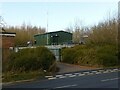
Cotgrave electricity substation
Originally built to serve Cotgrave Colliery, recently upgraded as a result of the expansion of housing in Cotgrave.
Image: © Alan Murray-Rust
Taken: 9 Jan 2022
0.11 miles
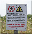
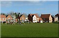
7
Sports ground, Cotgrave
As the sign states, owned and operated by Cotgrave Town Council.
Image: © Alan Murray-Rust
Taken: 9 Jan 2022
0.11 miles
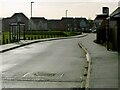
8
Harvest Drive Play Area, Hollygate, Cotgrave
One of several open spaces in this new housing development.
Image: © Alan Murray-Rust
Taken: 9 Jan 2022
0.11 miles
9
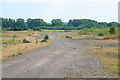
Cotgrave colliery site
This colliery closed in 1993 and there is little left on the surface to show what was once here apart from an old railway track (middle distance) and air vent covers (left). A large proportion of the site is being developed into a country park along the Grantham Canal which follows the line of the trees. (See Image) Some of the site has been redeveloped as a light industry estate on Holygate Lane.
Image: © Kate Jewell
Taken: 3 Jul 2006
0.13 miles
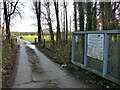
10
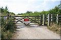
Cotgrave Country Park entrance
This entrance is on Collier's Way, the old main entrance road to the mine.
Image: © Kate Jewell
Taken: 3 Jul 2006
0.13 miles