IMAGES TAKEN NEAR TO
Bunnison Lane, NOTTINGHAM, NG12 3FF
Introduction
This page details the photographs taken nearby to Bunnison Lane, NG12 3FF by members of the Geograph project.
The Geograph project started in 2005 with the aim of publishing, organising and preserving representative images for every square kilometre of Great Britain, Ireland and the Isle of Man.

There are currently over 7.5m images from over14,400 individuals and you can help contribute to the project by visiting https://www.geograph.org.uk
Image Map
Images are licensed for reuse under creativecommons.org/licenses/by-sa/2.0
Notes
- Clicking on the map will re-center to the selected point.
- The higher the marker number, the further away the image location is from the centre of the postcode.
Image Listing (66 Images Found)
Images are licensed for reuse under creativecommons.org/licenses/by-sa/2.0
Image
Details
Distance
1
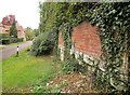
Wall, Colston Bassett
The brick wall on a stone footing is also shown in Image, taken at the same spot on Bunnison Lane.
Image: © Derek Harper
Taken: 11 Oct 2014
0.02 miles
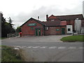
2
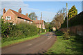
Bunnison Lane, Colston Bassett
Looking towards the Church of St John the Divine and the centre of the village.
Image: © Kate Jewell
Taken: 30 Apr 2010
0.03 miles
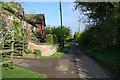
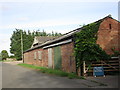
3
Bakers Lane, Colston Bassett
With Manor House Farm to the left.
Image: © Kate Jewell
Taken: 30 Apr 2010
0.03 miles
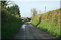
4
Bakers Lane, Colston Bassett
At the junction with Bunnison Lane. On the right is the wall mentioned at Image
Image: © Derek Harper
Taken: 11 Oct 2014
0.04 miles
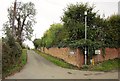
5
Bunnison Lane, Colston Bassett
Looking towards the centre of the village.
The fine brick wall to the right bounds Manor House Farm, once the home of Colonel Francis Hacker, a staunch Parliamentarian in the Civil War of the mid 17th century. Colonel Hacker was directly involved supervised arrangements for the execution of King Charles I.
Image: © Kate Jewell
Taken: 30 Apr 2010
0.05 miles
7
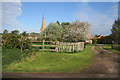
Entrance to Church Farm
With the Church of St John the Divine in the distance.
Image: © Kate Jewell
Taken: 30 Apr 2010
0.07 miles
8
Stile, Colston Bassett
Whoever designed this stile obviously didn't bother to try and use it. The worst feature is the single crosspiece which is too low; this problem is exacerbated by the extraordinary decision to have the top rung v-shaped and sloping upwards. Getting your trailing leg over the top is extremely awkward. This looks a fairly recent stile; ironically, the 2009 Conservation Area Apprailsal and management Plan acknowledged that "public footpaths and other rights of way within and adjacent to the Conservation Area play a vital role in allowing people to enjoy and experience the area. It is important that these paths are well maintained, clearly marked and made accessible ... Footpaths and pavements are in poor condition in places" http://www.rushcliffe.gov.uk/media/rushcliffe/media/documents/pdf/planningandbuilding/conservationareas/Colston_Bassett_Conservation_Area_Appraisal_and_Management_Plan.pdf . The right of way is Colston Bassett footpath 9; in the background are houses on Bunnison Lane.
Image: © Derek Harper
Taken: 11 Oct 2014
0.07 miles
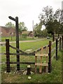
9
Colston Bassett Dairy
on the junction of Langar Ln and Harby Ln. This Dairy is famous for the beautiful "Blue Stilton" it produces
Image: © Tom Courtney
Taken: 18 Sep 2005
0.08 miles
10
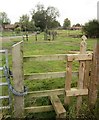
Stiles, Colston Bassett
In the background is the awkward stile shown in Image], in the foreground is another one. Again the single crosspiece is far too low for comfort. On the right are buildings at Manor House Farm.
Image: © Derek Harper
Taken: 11 Oct 2014
0.08 miles