IMAGES TAKEN NEAR TO
Back Lane, NOTTINGHAM, NG12 3AD
Introduction
This page details the photographs taken nearby to Back Lane, NG12 3AD by members of the Geograph project.
The Geograph project started in 2005 with the aim of publishing, organising and preserving representative images for every square kilometre of Great Britain, Ireland and the Isle of Man.

There are currently over 7.5m images from over14,400 individuals and you can help contribute to the project by visiting https://www.geograph.org.uk
Image Map
Images are licensed for reuse under creativecommons.org/licenses/by-sa/2.0
Notes
- Clicking on the map will re-center to the selected point.
- The higher the marker number, the further away the image location is from the centre of the postcode.
Image Listing (69 Images Found)
Images are licensed for reuse under creativecommons.org/licenses/by-sa/2.0
Image
Details
Distance
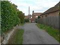
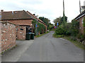
3
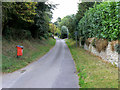
Back Lane, Cropwell Butler
A Back Lane is a common feature of medieval villages, running parallel to the main street, and normally originally without fronting dwellings. Looking north from The Posts. A modern primary use of the lane is identified by the presence of the red bin.
Image: © Alan Murray-Rust
Taken: 2 Sep 2011
0.03 miles
5
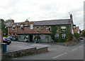
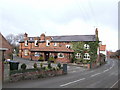
The Plough, Cropwell Butler
This looks to have developed out of a series of cottages, although it is shown as a single entity on the earliest available OS 1:2500 map of 1884.
Image: © Alan Murray-Rust
Taken: 2 Sep 2011
0.03 miles
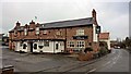
7
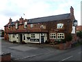
Main Street, Cropwell Butler
This is remarkably typical of villages in southern Nottinghamshire, built largely in brick.
Image: © Alan Murray-Rust
Taken: 2 Sep 2011
0.04 miles
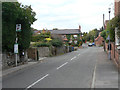
8
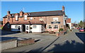
The Posts, Cropwell Butler
A cross alley linking Main Street with Back Lane
Image: © Alan Murray-Rust
Taken: 2 Sep 2011
0.04 miles
9
Back Lane, Cropwell Butler
A Back Lane is a common feature of medieval villages, running parallel to the main street, and normally originally without fronting dwellings. The long building on the left was originally a malthouse, part of the former Hollies Farm, and is called The Maltings.
Image: © Alan Murray-Rust
Taken: 2 Sep 2011
0.05 miles
10
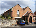
Chapel House, Cropwell Butler
It was quite difficult to assign a denomination to this former chapel. Although there is an 1845 date stone below the end of the valley gutter, the 1883 1:2500 OS maps does not even identify it as a chapel. The 1900 edition shows it simply as church, the 1919 version labels it Mission Church, and the 1972 version finally shows it as Chapel of St Peter (C of E). It appears that the village never had a proper church, although it nevertheless constitutes a civil parish.
I have found information http://southwellchurches.nottingham.ac.uk/tythby/hhistory.php subsequent to writing the above, which confirms that this was built as a chapel of ease within the parish of Tithby, by a local farmer. It closed in 1879, but was reopened in 1897 as St. Peter's Mission Church. It lasted in this form until 1972, since when the function of parish church has reverted to Tithby. United services are now held in the village's Methodist Church.
Image: © Alan Murray-Rust
Taken: 2 Sep 2011
0.05 miles