IMAGES TAKEN NEAR TO
Tithby Road, NOTTINGHAM, NG12 3AA
Introduction
This page details the photographs taken nearby to Tithby Road, NG12 3AA by members of the Geograph project.
The Geograph project started in 2005 with the aim of publishing, organising and preserving representative images for every square kilometre of Great Britain, Ireland and the Isle of Man.

There are currently over 7.5m images from over14,400 individuals and you can help contribute to the project by visiting https://www.geograph.org.uk
Image Map
Images are licensed for reuse under creativecommons.org/licenses/by-sa/2.0
Notes
- Clicking on the map will re-center to the selected point.
- The higher the marker number, the further away the image location is from the centre of the postcode.
Image Listing (55 Images Found)
Images are licensed for reuse under creativecommons.org/licenses/by-sa/2.0
Image
Details
Distance
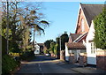
2
Cropwell Butler Methodist Chapel
This is the 1905 extension of the chapel facing onto Tithby Road.
Image: © Alan Murray-Rust
Taken: 2 Sep 2011
0.01 miles
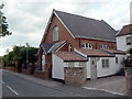
3
Wesleyan Methodist chapel, Cropwell Butler
With a date stone for 1903. Anglican worshippers must travel to the church of All Saints in the neighbouring village of Tithby.
Image: © Tim Heaton
Taken: 22 Mar 2021
0.02 miles
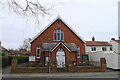
4
Cropwell Butler Methodist Chapel
This is the rear view, showing the older part of the building, which looks to date from the early part of the 19th century, and was set back from the main road. In 1905 the chapel was significantly extended http://www.geograph.org.uk/photo/2590698.
Image: © Alan Murray-Rust
Taken: 2 Sep 2011
0.02 miles
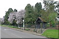
5
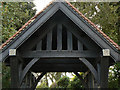
Cropwell Butler Cemetery lych gate
Erected as a memorial to the fallen of the First World War. Despite the date of 1919, it was actually erected in 1920. It is Listed Grade II.
Image: © Alan Murray-Rust
Taken: 2 Sep 2011
0.06 miles
6
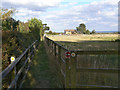
Field edge, Cropwell Butler
The reason for maintaining the boundary fence clear of the hedge is unclear. The gap appears to be used as a footpath although it is not a public right of way, as the signs indicate.
Image: © Alan Murray-Rust
Taken: 2 Sep 2011
0.06 miles
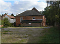
7
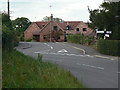
Rookery Farm
A large group of former farm buildings now converted into residential property.
Image: © Alan Murray-Rust
Taken: 2 Sep 2011
0.06 miles
8
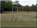
Portal frame stile
Constructed to carry the electrified tape of the top of walkers.
Image: © Alan Murray-Rust
Taken: 2 Sep 2011
0.07 miles
9
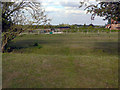
Paddocks near The Rookery
Showing substantial traces of ridge and furrow cultivation.
Image: © Alan Murray-Rust
Taken: 2 Sep 2011
0.07 miles
10
Cemetery, Cropwell Butler
Or, if you prefer not to stay, buses to Bingham, Radcliffe, or Cotgrave.
Image: © Tim Heaton
Taken: 22 Mar 2021
0.07 miles