IMAGES TAKEN NEAR TO
Main Road, NG12 2PY
Introduction
This page details the photographs taken nearby to Main Road, NG12 2PY by members of the Geograph project.
The Geograph project started in 2005 with the aim of publishing, organising and preserving representative images for every square kilometre of Great Britain, Ireland and the Isle of Man.

There are currently over 7.5m images from over14,400 individuals and you can help contribute to the project by visiting https://www.geograph.org.uk
Image Map
Images are licensed for reuse under creativecommons.org/licenses/by-sa/2.0
Notes
- Clicking on the map will re-center to the selected point.
- The higher the marker number, the further away the image location is from the centre of the postcode.
Image Listing (2 Images Found)
Images are licensed for reuse under creativecommons.org/licenses/by-sa/2.0
Image
Details
Distance
2
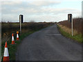
Henson Lane, Saxondale
This section of the lane will replaced by a completely different alignment crossing the new A46 on an overbridge and joining the current A46 near High Thorpe.
Image: © Alan Murray-Rust
Taken: 6 Dec 2009
0.25 miles